RPV Rancho Palos Verdes, California, USA - Earthquake Result Viewer
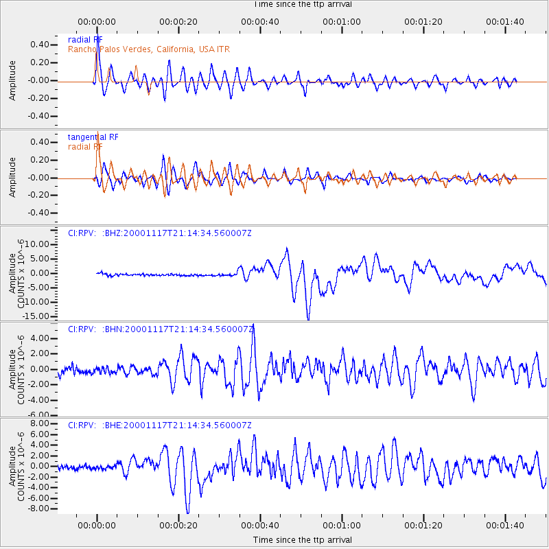
Earthquake location: New Britain Region, P.N.G.
Earthquake latitude/longitude: -5.5/151.8
Earthquake time(UTC): 2000/11/17 (322) 21:01:56 GMT
Earthquake Depth: 33 km
Earthquake Magnitude: 6.2 MB, 8.0 MS, 7.6 MW, 6.9 ME
Earthquake Catalog/Contributor: WHDF/NEIC
Network: CI Caltech Regional Seismic Network
Station: RPV Rancho Palos Verdes, California, USA
Lat/Lon: 33.74 N/118.40 W
Elevation: 64 m
Distance: 92.9 deg
Az: 56.542 deg
Baz: 265.345 deg
Ray Param: 0.04136382
Estimated Moho Depth: 25.5 km
Estimated Crust Vp/Vs: 1.79
Assumed Crust Vp: 6.048 km/s
Estimated Crust Vs: 3.374 km/s
Estimated Crust Poisson's Ratio: 0.27
Radial Match: 90.15221 %
Radial Bump: 400
Transverse Match: 80.70612 %
Transverse Bump: 400
SOD ConfigId: 3744
Insert Time: 2010-03-05 22:05:38.464 +0000
GWidth: 2.5
Max Bumps: 400
Tol: 0.001

Signal To Noise

ChannelStoNSTALTA
CI:RPV: :BHN:20001117T21:14:34.560007Z0.61950753.3485514E-75.4051833E-7
CI:RPV: :BHE:20001117T21:14:34.560007Z0.6684512.588511E-73.8724022E-7
CI:RPV: :BHZ:20001117T21:14:34.560007Z2.14331726.617492E-73.0875E-7
Arrivals
Ps3.4 SECOND
PpPs12 SECOND
PsPs/PpSs15 SECOND