You are here: Home > Network List > CI - Caltech Regional Seismic Network Stations List
> Station RPV Rancho Palos Verdes, California, USA > Earthquake Result Viewer
RPV Rancho Palos Verdes, California, USA - Earthquake Result Viewer
| Earthquake location: |
Fiji Islands Region |
| Earthquake latitude/longitude: |
-17.7/-178.4 |
| Earthquake time(UTC): |
2006/02/02 (033) 12:48:43 GMT |
| Earthquake Depth: |
598 km |
| Earthquake Magnitude: |
5.9 MB, 6.7 MW, 6.7 MW |
| Earthquake Catalog/Contributor: |
WHDF/NEIC |
|
| Network: |
CI Caltech Regional Seismic Network |
| Station: |
RPV Rancho Palos Verdes, California, USA |
| Lat/Lon: |
33.74 N/118.40 W |
| Elevation: |
64 m |
|
| Distance: |
76.7 deg |
| Az: |
47.845 deg |
| Baz: |
237.982 deg |
| Ray Param: |
0.048890017 |
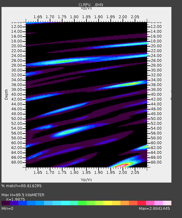
| Estimated Moho Depth: |
69.5 km |
| Estimated Crust Vp/Vs: |
1.99 |
| Assumed Crust Vp: |
6.048 km/s |
| Estimated Crust Vs: |
3.043 km/s |
| Estimated Crust Poisson's Ratio: |
0.33 |
|
| Radial Match: |
88.616295 % |
| Radial Bump: |
400 |
| Transverse Match: |
72.47921 % |
| Transverse Bump: |
400 |
| SOD ConfigId: |
4977 |
| Insert Time: |
2010-03-05 22:05:52.117 +0000 |
| GWidth: |
2.5 |
| Max Bumps: |
400 |
| Tol: |
0.001 |
|

Signal To Noise
| Channel | StoN | STA | LTA |
| CI:RPV: :BHN:20060202T12:59:03.210996Z | 1.537788 | 9.103775E-7 | 5.9200454E-7 |
| CI:RPV: :BHE:20060202T12:59:03.210996Z | 3.1222332 | 1.2938599E-6 | 4.1440205E-7 |
| CI:RPV: :BHZ:20060202T12:59:03.210996Z | 12.694588 | 3.868304E-6 | 3.0472071E-7 |
| Arrivals |
| Ps | 12 SECOND |
| PpPs | 34 SECOND |
| PsPs/PpSs | 45 SECOND |


