You are here: Home > Network List > CI - Caltech Regional Seismic Network Stations List
> Station RPV Rancho Palos Verdes, California, USA > Earthquake Result Viewer
RPV Rancho Palos Verdes, California, USA - Earthquake Result Viewer
| Earthquake location: |
Tonga Islands Region |
| Earthquake latitude/longitude: |
-23.0/-174.7 |
| Earthquake time(UTC): |
2009/03/19 (078) 18:17:40 GMT |
| Earthquake Depth: |
34 km |
| Earthquake Magnitude: |
7.0 MB, 7.6 MS, 7.6 MW, 7.6 MW |
| Earthquake Catalog/Contributor: |
WHDF/NEIC |
|
| Network: |
CI Caltech Regional Seismic Network |
| Station: |
RPV Rancho Palos Verdes, California, USA |
| Lat/Lon: |
33.74 N/118.40 W |
| Elevation: |
64 m |
|
| Distance: |
77.8 deg |
| Az: |
45.141 deg |
| Baz: |
231.592 deg |
| Ray Param: |
0.0500209 |
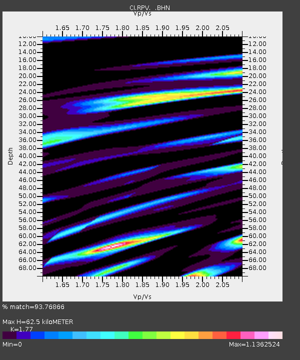
| Estimated Moho Depth: |
62.5 km |
| Estimated Crust Vp/Vs: |
1.77 |
| Assumed Crust Vp: |
6.048 km/s |
| Estimated Crust Vs: |
3.417 km/s |
| Estimated Crust Poisson's Ratio: |
0.27 |
|
| Radial Match: |
93.76866 % |
| Radial Bump: |
400 |
| Transverse Match: |
90.00127 % |
| Transverse Bump: |
400 |
| SOD ConfigId: |
2658 |
| Insert Time: |
2010-03-05 22:06:25.958 +0000 |
| GWidth: |
2.5 |
| Max Bumps: |
400 |
| Tol: |
0.001 |
|

Signal To Noise
| Channel | StoN | STA | LTA |
| CI:RPV: :BHN:20090319T18:29:03.701016Z | 11.782688 | 8.071244E-6 | 6.8500873E-7 |
| CI:RPV: :BHE:20090319T18:29:03.701016Z | 3.5755515 | 2.7343901E-6 | 7.647464E-7 |
| CI:RPV: :BHZ:20090319T18:29:03.701016Z | 2.4181392 | 2.9362805E-6 | 1.2142726E-6 |
| Arrivals |
| Ps | 8.2 SECOND |
| PpPs | 28 SECOND |
| PsPs/PpSs | 36 SECOND |


