You are here: Home > Network List > LD - Lamont-Doherty Cooperative Seismographic Network Stations List
> Station GEDE Greenville, DE, USA > Earthquake Result Viewer
GEDE Greenville, DE, USA - Earthquake Result Viewer
| Earthquake location: |
Southern Bolivia |
| Earthquake latitude/longitude: |
-19.3/-63.9 |
| Earthquake time(UTC): |
2017/02/21 (052) 14:09:04 GMT |
| Earthquake Depth: |
598 km |
| Earthquake Magnitude: |
6.5 Mww |
| Earthquake Catalog/Contributor: |
NEIC PDE/us |
|
| Network: |
LD Lamont-Doherty Cooperative Seismographic Network |
| Station: |
GEDE Greenville, DE, USA |
| Lat/Lon: |
39.81 N/75.64 W |
| Elevation: |
105 m |
|
| Distance: |
59.8 deg |
| Az: |
349.555 deg |
| Baz: |
167.155 deg |
| Ray Param: |
0.059539117 |
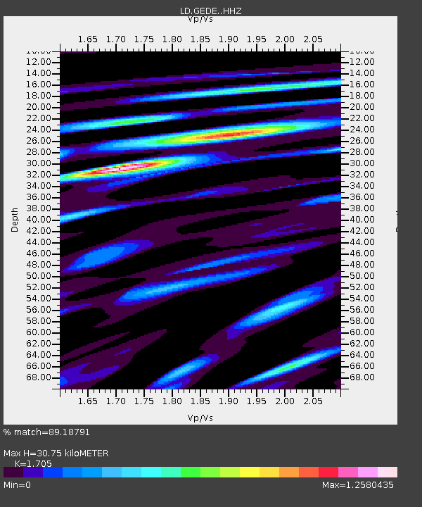
| Estimated Moho Depth: |
30.75 km |
| Estimated Crust Vp/Vs: |
1.71 |
| Assumed Crust Vp: |
6.287 km/s |
| Estimated Crust Vs: |
3.688 km/s |
| Estimated Crust Poisson's Ratio: |
0.24 |
|
| Radial Match: |
89.18791 % |
| Radial Bump: |
400 |
| Transverse Match: |
77.4571 % |
| Transverse Bump: |
400 |
| SOD ConfigId: |
11737051 |
| Insert Time: |
2019-04-26 19:28:03.396 +0000 |
| GWidth: |
2.5 |
| Max Bumps: |
400 |
| Tol: |
0.001 |
|

Signal To Noise
| Channel | StoN | STA | LTA |
| LD:GEDE: :HHZ:20170221T14:17:42.42001Z | 42.504826 | 3.2245123E-6 | 7.586227E-8 |
| LD:GEDE: :HHN:20170221T14:17:42.42001Z | 12.639295 | 1.6680502E-6 | 1.3197337E-7 |
| LD:GEDE: :HHE:20170221T14:17:42.42001Z | 3.2221134 | 3.9170388E-7 | 1.2156738E-7 |
| Arrivals |
| Ps | 3.6 SECOND |
| PpPs | 13 SECOND |
| PsPs/PpSs | 16 SECOND |


