You are here: Home > Network List > LD - Lamont-Doherty Cooperative Seismographic Network Stations List
> Station HCNY Howe Caverns, Cobleskill, NY > Earthquake Result Viewer
HCNY Howe Caverns, Cobleskill, NY - Earthquake Result Viewer
| Earthquake location: |
Southern Bolivia |
| Earthquake latitude/longitude: |
-19.3/-63.9 |
| Earthquake time(UTC): |
2017/02/21 (052) 14:09:04 GMT |
| Earthquake Depth: |
598 km |
| Earthquake Magnitude: |
6.5 Mww |
| Earthquake Catalog/Contributor: |
NEIC PDE/us |
|
| Network: |
LD Lamont-Doherty Cooperative Seismographic Network |
| Station: |
HCNY Howe Caverns, Cobleskill, NY |
| Lat/Lon: |
42.70 N/74.40 W |
| Elevation: |
273 m |
|
| Distance: |
62.4 deg |
| Az: |
351.283 deg |
| Baz: |
168.803 deg |
| Ray Param: |
0.057918765 |
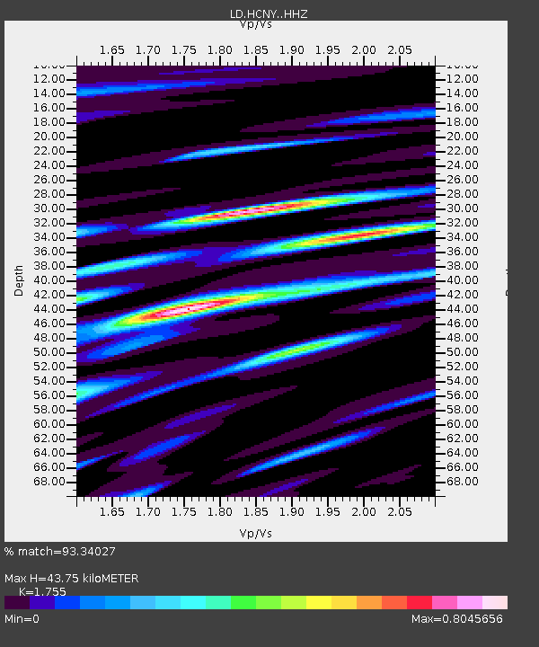
| Estimated Moho Depth: |
43.75 km |
| Estimated Crust Vp/Vs: |
1.75 |
| Assumed Crust Vp: |
6.419 km/s |
| Estimated Crust Vs: |
3.658 km/s |
| Estimated Crust Poisson's Ratio: |
0.26 |
|
| Radial Match: |
93.34027 % |
| Radial Bump: |
395 |
| Transverse Match: |
82.522255 % |
| Transverse Bump: |
400 |
| SOD ConfigId: |
11737051 |
| Insert Time: |
2019-04-26 19:28:05.275 +0000 |
| GWidth: |
2.5 |
| Max Bumps: |
400 |
| Tol: |
0.001 |
|

Signal To Noise
| Channel | StoN | STA | LTA |
| LD:HCNY: :HHZ:20170221T14:17:59.51498Z | 16.395937 | 2.7263395E-6 | 1.6628141E-7 |
| LD:HCNY: :HHN:20170221T14:17:59.51498Z | 9.937397 | 1.2022884E-6 | 1.2098626E-7 |
| LD:HCNY: :HHE:20170221T14:17:59.51498Z | 2.411413 | 2.4772228E-7 | 1.02729096E-7 |
| Arrivals |
| Ps | 5.4 SECOND |
| PpPs | 18 SECOND |
| PsPs/PpSs | 23 SECOND |


