You are here: Home > Network List > LD - Lamont-Doherty Cooperative Seismographic Network Stations List
> Station PAL Palisades, New York > Earthquake Result Viewer
PAL Palisades, New York - Earthquake Result Viewer
| Earthquake location: |
Southern Bolivia |
| Earthquake latitude/longitude: |
-19.3/-63.9 |
| Earthquake time(UTC): |
2017/02/21 (052) 14:09:04 GMT |
| Earthquake Depth: |
598 km |
| Earthquake Magnitude: |
6.5 Mww |
| Earthquake Catalog/Contributor: |
NEIC PDE/us |
|
| Network: |
LD Lamont-Doherty Cooperative Seismographic Network |
| Station: |
PAL Palisades, New York |
| Lat/Lon: |
41.01 N/73.91 W |
| Elevation: |
66 m |
|
| Distance: |
60.7 deg |
| Az: |
351.325 deg |
| Baz: |
169.149 deg |
| Ray Param: |
0.05898317 |
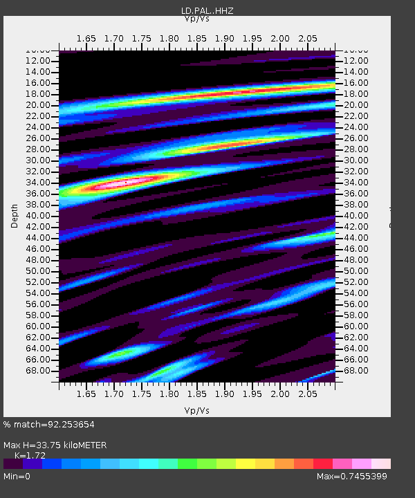
| Estimated Moho Depth: |
33.75 km |
| Estimated Crust Vp/Vs: |
1.72 |
| Assumed Crust Vp: |
6.472 km/s |
| Estimated Crust Vs: |
3.763 km/s |
| Estimated Crust Poisson's Ratio: |
0.24 |
|
| Radial Match: |
92.253654 % |
| Radial Bump: |
354 |
| Transverse Match: |
82.045044 % |
| Transverse Bump: |
400 |
| SOD ConfigId: |
11737051 |
| Insert Time: |
2019-04-26 19:28:13.998 +0000 |
| GWidth: |
2.5 |
| Max Bumps: |
400 |
| Tol: |
0.001 |
|

Signal To Noise
| Channel | StoN | STA | LTA |
| LD:PAL: :HHZ:20170221T14:17:48.31802Z | 27.039747 | 3.728155E-6 | 1.3787684E-7 |
| LD:PAL: :HHN:20170221T14:17:48.31802Z | 13.012249 | 1.9279873E-6 | 1.4816712E-7 |
| LD:PAL: :HHE:20170221T14:17:48.31802Z | 3.019905 | 4.3615893E-7 | 1.4442801E-7 |
| Arrivals |
| Ps | 3.9 SECOND |
| PpPs | 14 SECOND |
| PsPs/PpSs | 17 SECOND |


