You are here: Home > Network List > CI - Caltech Regional Seismic Network Stations List
> Station RPV Rancho Palos Verdes, California, USA > Earthquake Result Viewer
RPV Rancho Palos Verdes, California, USA - Earthquake Result Viewer
| Earthquake location: |
New Britain Region, P.N.G. |
| Earthquake latitude/longitude: |
-5.4/152.0 |
| Earthquake time(UTC): |
2000/11/17 (322) 21:45:51 GMT |
| Earthquake Depth: |
33 km |
| Earthquake Magnitude: |
5.7 MB |
| Earthquake Catalog/Contributor: |
WHDF/NEIC |
|
| Network: |
CI Caltech Regional Seismic Network |
| Station: |
RPV Rancho Palos Verdes, California, USA |
| Lat/Lon: |
33.74 N/118.40 W |
| Elevation: |
64 m |
|
| Distance: |
92.6 deg |
| Az: |
56.523 deg |
| Baz: |
265.273 deg |
| Ray Param: |
0.04141015 |
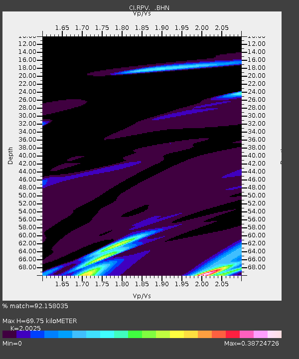
| Estimated Moho Depth: |
69.75 km |
| Estimated Crust Vp/Vs: |
2.00 |
| Assumed Crust Vp: |
6.048 km/s |
| Estimated Crust Vs: |
3.02 km/s |
| Estimated Crust Poisson's Ratio: |
0.33 |
|
| Radial Match: |
92.158035 % |
| Radial Bump: |
307 |
| Transverse Match: |
82.44421 % |
| Transverse Bump: |
357 |
| SOD ConfigId: |
3770 |
| Insert Time: |
2010-03-05 22:07:01.947 +0000 |
| GWidth: |
2.5 |
| Max Bumps: |
400 |
| Tol: |
0.001 |
|
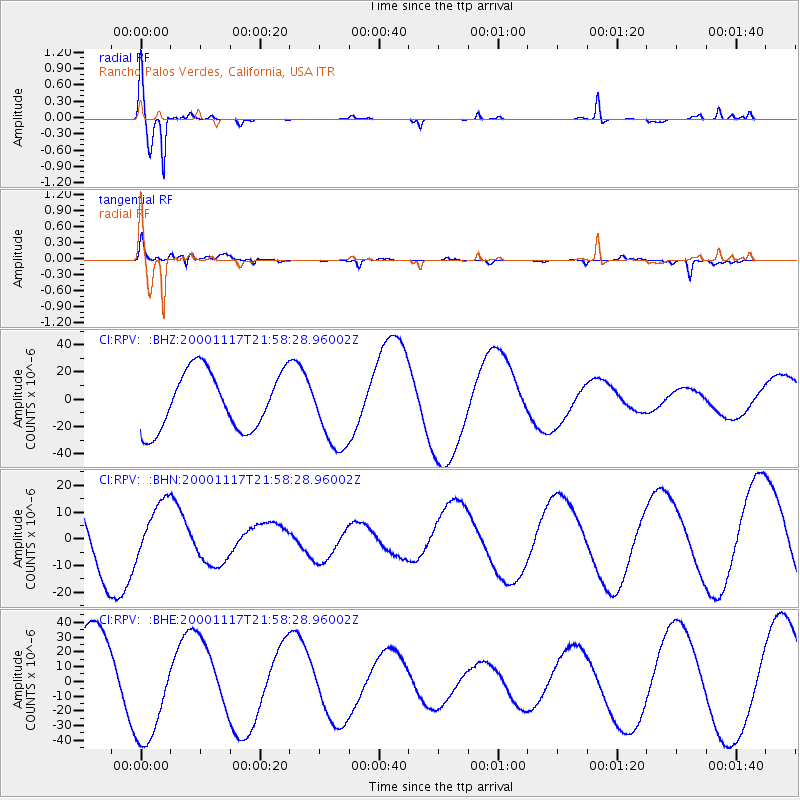
Signal To Noise
| Channel | StoN | STA | LTA |
| CI:RPV: :BHN:20001117T21:58:28.96002Z | 0.7170618 | 1.0670703E-5 | 1.4881148E-5 |
| CI:RPV: :BHE:20001117T21:58:28.96002Z | 1.2357903 | 3.651588E-5 | 2.9548608E-5 |
| CI:RPV: :BHZ:20001117T21:58:28.96002Z | 1.3098333 | 2.7755426E-5 | 2.1190044E-5 |
| Arrivals |
| Ps | 12 SECOND |
| PpPs | 34 SECOND |
| PsPs/PpSs | 46 SECOND |


