You are here: Home > Network List > CI - Caltech Regional Seismic Network Stations List
> Station RPV Rancho Palos Verdes, California, USA > Earthquake Result Viewer
RPV Rancho Palos Verdes, California, USA - Earthquake Result Viewer
| Earthquake location: |
New Ireland Region, P.N.G. |
| Earthquake latitude/longitude: |
-5.1/153.2 |
| Earthquake time(UTC): |
2000/11/16 (321) 05:47:34 GMT |
| Earthquake Depth: |
33 km |
| Earthquake Magnitude: |
5.6 MB |
| Earthquake Catalog/Contributor: |
WHDF/NEIC |
|
| Network: |
CI Caltech Regional Seismic Network |
| Station: |
RPV Rancho Palos Verdes, California, USA |
| Lat/Lon: |
33.74 N/118.40 W |
| Elevation: |
64 m |
|
| Distance: |
91.5 deg |
| Az: |
56.429 deg |
| Baz: |
264.855 deg |
| Ray Param: |
0.041595243 |
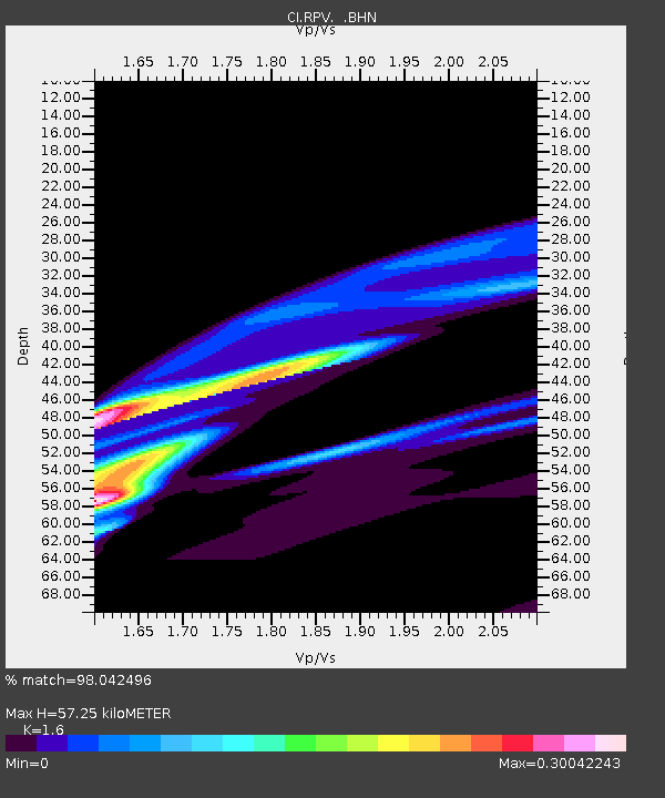
| Estimated Moho Depth: |
57.25 km |
| Estimated Crust Vp/Vs: |
1.60 |
| Assumed Crust Vp: |
6.048 km/s |
| Estimated Crust Vs: |
3.78 km/s |
| Estimated Crust Poisson's Ratio: |
0.18 |
|
| Radial Match: |
98.042496 % |
| Radial Bump: |
271 |
| Transverse Match: |
85.93701 % |
| Transverse Bump: |
400 |
| SOD ConfigId: |
3770 |
| Insert Time: |
2010-03-05 22:07:03.793 +0000 |
| GWidth: |
2.5 |
| Max Bumps: |
400 |
| Tol: |
0.001 |
|
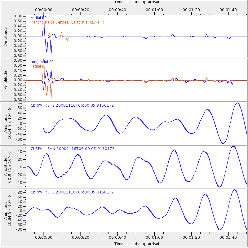
Signal To Noise
| Channel | StoN | STA | LTA |
| CI:RPV: :BHN:20001116T06:00:05.915017Z | 3.8103306 | 2.6568496E-5 | 6.972753E-6 |
| CI:RPV: :BHE:20001116T06:00:05.915017Z | 0.30298495 | 5.9484623E-6 | 1.9632864E-5 |
| CI:RPV: :BHZ:20001116T06:00:05.915017Z | 1.447178 | 2.8040266E-5 | 1.9375824E-5 |
| Arrivals |
| Ps | 5.8 SECOND |
| PpPs | 24 SECOND |
| PsPs/PpSs | 30 SECOND |


