You are here: Home > Network List > N4 - Central and EAstern US Network Stations List
> Station N49A Columbus Grove, OH, USA > Earthquake Result Viewer
N49A Columbus Grove, OH, USA - Earthquake Result Viewer
| Earthquake location: |
Southern Bolivia |
| Earthquake latitude/longitude: |
-19.3/-63.9 |
| Earthquake time(UTC): |
2017/02/21 (052) 14:09:04 GMT |
| Earthquake Depth: |
598 km |
| Earthquake Magnitude: |
6.5 Mww |
| Earthquake Catalog/Contributor: |
NEIC PDE/us |
|
| Network: |
N4 Central and EAstern US Network |
| Station: |
N49A Columbus Grove, OH, USA |
| Lat/Lon: |
40.92 N/84.18 W |
| Elevation: |
225 m |
|
| Distance: |
62.8 deg |
| Az: |
342.82 deg |
| Baz: |
158.396 deg |
| Ray Param: |
0.057690706 |
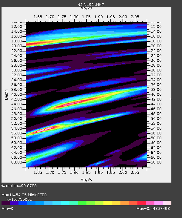
| Estimated Moho Depth: |
54.25 km |
| Estimated Crust Vp/Vs: |
1.68 |
| Assumed Crust Vp: |
6.498 km/s |
| Estimated Crust Vs: |
3.879 km/s |
| Estimated Crust Poisson's Ratio: |
0.22 |
|
| Radial Match: |
90.8788 % |
| Radial Bump: |
217 |
| Transverse Match: |
78.57271 % |
| Transverse Bump: |
400 |
| SOD ConfigId: |
11737051 |
| Insert Time: |
2019-04-26 19:29:36.513 +0000 |
| GWidth: |
2.5 |
| Max Bumps: |
400 |
| Tol: |
0.001 |
|

Signal To Noise
| Channel | StoN | STA | LTA |
| N4:N49A: :HHZ:20170221T14:18:01.870022Z | 43.084118 | 7.1365284E-6 | 1.6564174E-7 |
| N4:N49A: :HHN:20170221T14:18:01.870022Z | 19.538553 | 3.0863644E-6 | 1.5796279E-7 |
| N4:N49A: :HHE:20170221T14:18:01.870022Z | 10.944494 | 1.5209558E-6 | 1.3896995E-7 |
| Arrivals |
| Ps | 5.9 SECOND |
| PpPs | 21 SECOND |
| PsPs/PpSs | 27 SECOND |


