You are here: Home > Network List > N4 - Central and EAstern US Network Stations List
> Station P53A Whipple, OH, USA > Earthquake Result Viewer
P53A Whipple, OH, USA - Earthquake Result Viewer
| Earthquake location: |
Southern Bolivia |
| Earthquake latitude/longitude: |
-19.3/-63.9 |
| Earthquake time(UTC): |
2017/02/21 (052) 14:09:04 GMT |
| Earthquake Depth: |
598 km |
| Earthquake Magnitude: |
6.5 Mww |
| Earthquake Catalog/Contributor: |
NEIC PDE/us |
|
| Network: |
N4 Central and EAstern US Network |
| Station: |
P53A Whipple, OH, USA |
| Lat/Lon: |
39.49 N/81.39 W |
| Elevation: |
270 m |
|
| Distance: |
60.7 deg |
| Az: |
344.533 deg |
| Baz: |
161.003 deg |
| Ray Param: |
0.058976494 |
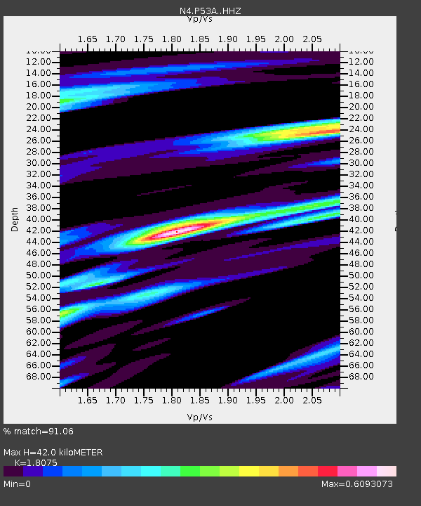
| Estimated Moho Depth: |
42.0 km |
| Estimated Crust Vp/Vs: |
1.81 |
| Assumed Crust Vp: |
6.207 km/s |
| Estimated Crust Vs: |
3.434 km/s |
| Estimated Crust Poisson's Ratio: |
0.28 |
|
| Radial Match: |
91.06 % |
| Radial Bump: |
380 |
| Transverse Match: |
79.52022 % |
| Transverse Bump: |
373 |
| SOD ConfigId: |
11737051 |
| Insert Time: |
2019-04-26 19:29:48.633 +0000 |
| GWidth: |
2.5 |
| Max Bumps: |
400 |
| Tol: |
0.001 |
|

Signal To Noise
| Channel | StoN | STA | LTA |
| N4:P53A: :HHZ:20170221T14:17:48.379971Z | 20.35959 | 4.954853E-6 | 2.4336703E-7 |
| N4:P53A: :HHN:20170221T14:17:48.379971Z | 10.132994 | 2.0075781E-6 | 1.981229E-7 |
| N4:P53A: :HHE:20170221T14:17:48.379971Z | 4.958866 | 6.7695515E-7 | 1.365141E-7 |
| Arrivals |
| Ps | 5.7 SECOND |
| PpPs | 18 SECOND |
| PsPs/PpSs | 24 SECOND |


