You are here: Home > Network List > CI - Caltech Regional Seismic Network Stations List
> Station RPV Rancho Palos Verdes, California, USA > Earthquake Result Viewer
RPV Rancho Palos Verdes, California, USA - Earthquake Result Viewer
| Earthquake location: |
Kuril Islands |
| Earthquake latitude/longitude: |
44.3/148.4 |
| Earthquake time(UTC): |
2001/05/25 (145) 00:40:50 GMT |
| Earthquake Depth: |
33 km |
| Earthquake Magnitude: |
6.1 MB, 6.7 MS, 6.7 MW, 6.6 MW |
| Earthquake Catalog/Contributor: |
WHDF/NEIC |
|
| Network: |
CI Caltech Regional Seismic Network |
| Station: |
RPV Rancho Palos Verdes, California, USA |
| Lat/Lon: |
33.74 N/118.40 W |
| Elevation: |
64 m |
|
| Distance: |
69.4 deg |
| Az: |
62.69 deg |
| Baz: |
309.996 deg |
| Ray Param: |
0.055594034 |
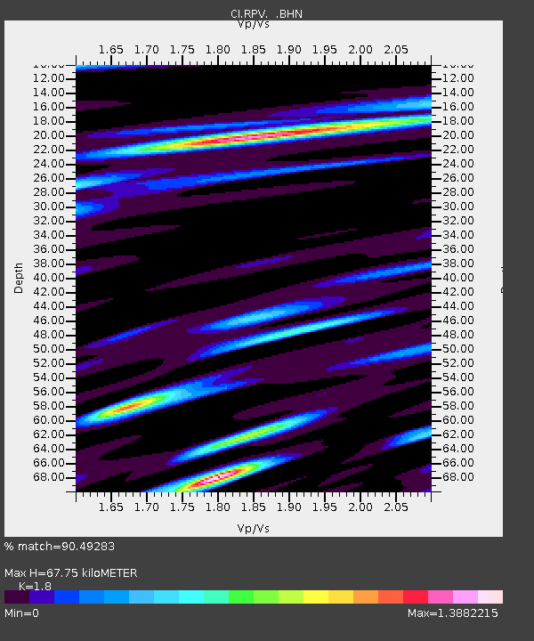
| Estimated Moho Depth: |
67.75 km |
| Estimated Crust Vp/Vs: |
1.80 |
| Assumed Crust Vp: |
6.048 km/s |
| Estimated Crust Vs: |
3.36 km/s |
| Estimated Crust Poisson's Ratio: |
0.28 |
|
| Radial Match: |
90.49283 % |
| Radial Bump: |
400 |
| Transverse Match: |
89.2145 % |
| Transverse Bump: |
400 |
| SOD ConfigId: |
3770 |
| Insert Time: |
2010-03-05 22:07:21.555 +0000 |
| GWidth: |
2.5 |
| Max Bumps: |
400 |
| Tol: |
0.001 |
|

Signal To Noise
| Channel | StoN | STA | LTA |
| CI:RPV: :BHN:20010525T00:51:24.597009Z | 1.3601172 | 2.9524048E-7 | 2.1706988E-7 |
| CI:RPV: :BHE:20010525T00:51:24.597009Z | 1.2450987 | 3.528711E-7 | 2.834081E-7 |
| CI:RPV: :BHZ:20010525T00:51:24.597009Z | 1.1517293 | 2.2150682E-7 | 1.9232542E-7 |
| Arrivals |
| Ps | 9.3 SECOND |
| PpPs | 30 SECOND |
| PsPs/PpSs | 40 SECOND |


