You are here: Home > Network List > N4 - Central and EAstern US Network Stations List
> Station V61A Roper, NC, USA > Earthquake Result Viewer
V61A Roper, NC, USA - Earthquake Result Viewer
| Earthquake location: |
Southern Bolivia |
| Earthquake latitude/longitude: |
-19.3/-63.9 |
| Earthquake time(UTC): |
2017/02/21 (052) 14:09:04 GMT |
| Earthquake Depth: |
598 km |
| Earthquake Magnitude: |
6.5 Mww |
| Earthquake Catalog/Contributor: |
NEIC PDE/us |
|
| Network: |
N4 Central and EAstern US Network |
| Station: |
V61A Roper, NC, USA |
| Lat/Lon: |
35.79 N/76.58 W |
| Elevation: |
4.0 m |
|
| Distance: |
56.1 deg |
| Az: |
347.582 deg |
| Baz: |
165.532 deg |
| Ray Param: |
0.061827183 |
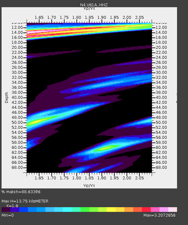
| Estimated Moho Depth: |
13.75 km |
| Estimated Crust Vp/Vs: |
1.60 |
| Assumed Crust Vp: |
6.565 km/s |
| Estimated Crust Vs: |
4.103 km/s |
| Estimated Crust Poisson's Ratio: |
0.18 |
|
| Radial Match: |
88.63396 % |
| Radial Bump: |
246 |
| Transverse Match: |
64.247055 % |
| Transverse Bump: |
306 |
| SOD ConfigId: |
11737051 |
| Insert Time: |
2019-04-26 19:30:19.806 +0000 |
| GWidth: |
2.5 |
| Max Bumps: |
400 |
| Tol: |
0.001 |
|

Signal To Noise
| Channel | StoN | STA | LTA |
| N4:V61A: :HHZ:20170221T14:17:17.369991Z | 11.544188 | 4.6806435E-6 | 4.0545459E-7 |
| N4:V61A: :HHN:20170221T14:17:17.369991Z | 2.873613 | 1.5639806E-6 | 5.4425584E-7 |
| N4:V61A: :HHE:20170221T14:17:17.369991Z | 1.8611631 | 1.6544783E-6 | 8.889486E-7 |
| Arrivals |
| Ps | 1.3 SECOND |
| PpPs | 5.2 SECOND |
| PsPs/PpSs | 6.5 SECOND |


