You are here: Home > Network List > N4 - Central and EAstern US Network Stations List
> Station X51A Calhoun, GA, USA > Earthquake Result Viewer
X51A Calhoun, GA, USA - Earthquake Result Viewer
| Earthquake location: |
Southern Bolivia |
| Earthquake latitude/longitude: |
-19.3/-63.9 |
| Earthquake time(UTC): |
2017/02/21 (052) 14:09:04 GMT |
| Earthquake Depth: |
598 km |
| Earthquake Magnitude: |
6.5 Mww |
| Earthquake Catalog/Contributor: |
NEIC PDE/us |
|
| Network: |
N4 Central and EAstern US Network |
| Station: |
X51A Calhoun, GA, USA |
| Lat/Lon: |
34.57 N/84.86 W |
| Elevation: |
214 m |
|
| Distance: |
57.1 deg |
| Az: |
339.427 deg |
| Baz: |
156.284 deg |
| Ray Param: |
0.061165888 |
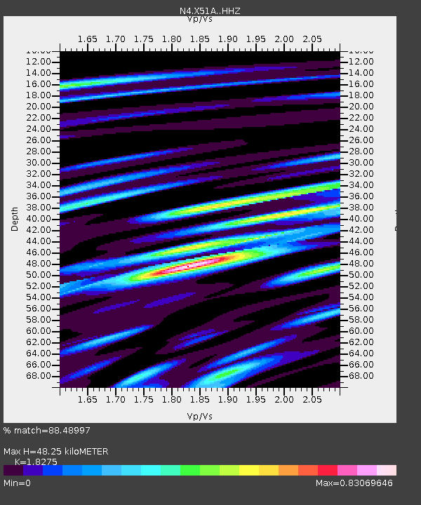
| Estimated Moho Depth: |
48.25 km |
| Estimated Crust Vp/Vs: |
1.83 |
| Assumed Crust Vp: |
6.35 km/s |
| Estimated Crust Vs: |
3.475 km/s |
| Estimated Crust Poisson's Ratio: |
0.29 |
|
| Radial Match: |
88.48997 % |
| Radial Bump: |
400 |
| Transverse Match: |
68.609886 % |
| Transverse Bump: |
400 |
| SOD ConfigId: |
11737051 |
| Insert Time: |
2019-04-26 19:30:24.143 +0000 |
| GWidth: |
2.5 |
| Max Bumps: |
400 |
| Tol: |
0.001 |
|

Signal To Noise
| Channel | StoN | STA | LTA |
| N4:X51A: :HHZ:20170221T14:17:24.640011Z | 41.80034 | 5.458723E-6 | 1.3059041E-7 |
| N4:X51A: :HHN:20170221T14:17:24.640011Z | 14.730967 | 3.0010272E-6 | 2.0372235E-7 |
| N4:X51A: :HHE:20170221T14:17:24.640011Z | 11.381246 | 1.6262895E-6 | 1.4289205E-7 |
| Arrivals |
| Ps | 6.6 SECOND |
| PpPs | 21 SECOND |
| PsPs/PpSs | 27 SECOND |


