You are here: Home > Network List > N4 - Central and EAstern US Network Stations List
> Station Y57A Sumter, SC, USA > Earthquake Result Viewer
Y57A Sumter, SC, USA - Earthquake Result Viewer
| Earthquake location: |
Southern Bolivia |
| Earthquake latitude/longitude: |
-19.3/-63.9 |
| Earthquake time(UTC): |
2017/02/21 (052) 14:09:04 GMT |
| Earthquake Depth: |
598 km |
| Earthquake Magnitude: |
6.5 Mww |
| Earthquake Catalog/Contributor: |
NEIC PDE/us |
|
| Network: |
N4 Central and EAstern US Network |
| Station: |
Y57A Sumter, SC, USA |
| Lat/Lon: |
34.02 N/80.39 W |
| Elevation: |
56 m |
|
| Distance: |
55.3 deg |
| Az: |
343.33 deg |
| Baz: |
160.96 deg |
| Ray Param: |
0.062315334 |
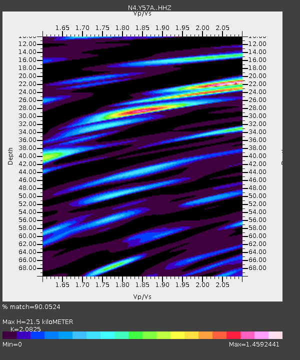
| Estimated Moho Depth: |
21.5 km |
| Estimated Crust Vp/Vs: |
2.08 |
| Assumed Crust Vp: |
6.419 km/s |
| Estimated Crust Vs: |
3.082 km/s |
| Estimated Crust Poisson's Ratio: |
0.35 |
|
| Radial Match: |
90.0524 % |
| Radial Bump: |
400 |
| Transverse Match: |
72.16986 % |
| Transverse Bump: |
400 |
| SOD ConfigId: |
11737051 |
| Insert Time: |
2019-04-26 19:30:28.679 +0000 |
| GWidth: |
2.5 |
| Max Bumps: |
400 |
| Tol: |
0.001 |
|

Signal To Noise
| Channel | StoN | STA | LTA |
| N4:Y57A: :HHZ:20170221T14:17:11.929989Z | 16.553503 | 3.914105E-6 | 2.3645175E-7 |
| N4:Y57A: :HHN:20170221T14:17:11.929989Z | 7.6437945 | 2.3056111E-6 | 3.0163176E-7 |
| N4:Y57A: :HHE:20170221T14:17:11.929989Z | 3.139602 | 1.0052851E-6 | 3.2019506E-7 |
| Arrivals |
| Ps | 3.8 SECOND |
| PpPs | 9.9 SECOND |
| PsPs/PpSs | 14 SECOND |


