You are here: Home > Network List > CI - Caltech Regional Seismic Network Stations List
> Station RPV Rancho Palos Verdes, California, USA > Earthquake Result Viewer
RPV Rancho Palos Verdes, California, USA - Earthquake Result Viewer

| Earthquake location: |
Fiji Islands Region |
| Earthquake latitude/longitude: |
-21.7/-176.7 |
| Earthquake time(UTC): |
2001/07/04 (185) 07:06:31 GMT |
| Earthquake Depth: |
185 km |
| Earthquake Magnitude: |
5.9 MB, 5.8 MS, 6.5 MW, 6.5 MW |
| Earthquake Catalog/Contributor: |
WHDF/NEIC |
|
| Network: |
CI Caltech Regional Seismic Network |
| Station: |
RPV Rancho Palos Verdes, California, USA |
| Lat/Lon: |
33.74 N/118.40 W |
| Elevation: |
64 m |
|
| Distance: |
78.2 deg |
| Az: |
46.396 deg |
| Baz: |
233.905 deg |
| Ray Param: |
0.049307596 |
| Estimated Moho Depth: |
35.25 km |
| Estimated Crust Vp/Vs: |
1.62 |
| Assumed Crust Vp: |
6.048 km/s |
| Estimated Crust Vs: |
3.728 km/s |
| Estimated Crust Poisson's Ratio: |
0.19 |
|
| Radial Match: |
92.144394 % |
| Radial Bump: |
400 |
| Transverse Match: |
81.78091 % |
| Transverse Bump: |
400 |
| SOD ConfigId: |
4714 |
| Insert Time: |
2010-03-05 22:07:38.605 +0000 |
| GWidth: |
2.5 |
| Max Bumps: |
400 |
| Tol: |
0.001 |
|
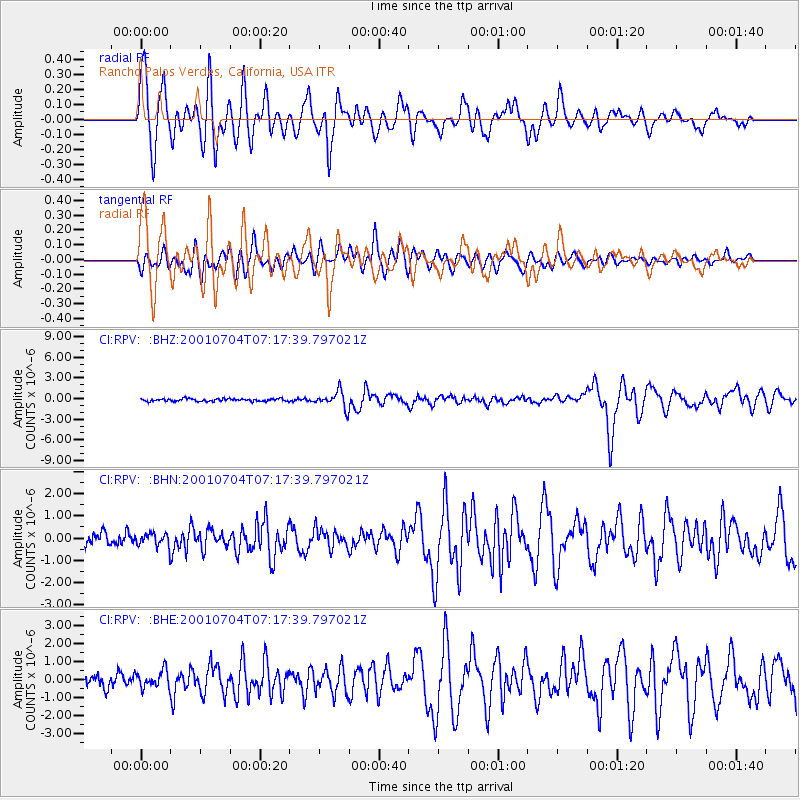
Signal To Noise
| Channel | StoN | STA | LTA |
| CI:RPV: :BHN:20010704T07:17:39.797021Z | 1.1567936 | 3.034375E-7 | 2.6230913E-7 |
| CI:RPV: :BHE:20010704T07:17:39.797021Z | 1.5130049 | 4.7843145E-7 | 3.1621278E-7 |
| CI:RPV: :BHZ:20010704T07:17:39.797021Z | 6.5876393 | 1.2027537E-6 | 1.8257734E-7 |
| Arrivals |
| Ps | 3.7 SECOND |
| PpPs | 15 SECOND |
| PsPs/PpSs | 19 SECOND |


