You are here: Home > Network List > NR - NARS Array Stations List
> Station NE218 Sowa > Earthquake Result Viewer
NE218 Sowa - Earthquake Result Viewer
| Earthquake location: |
Southern Bolivia |
| Earthquake latitude/longitude: |
-19.3/-63.9 |
| Earthquake time(UTC): |
2017/02/21 (052) 14:09:04 GMT |
| Earthquake Depth: |
598 km |
| Earthquake Magnitude: |
6.5 Mww |
| Earthquake Catalog/Contributor: |
NEIC PDE/us |
|
| Network: |
NR NARS Array |
| Station: |
NE218 Sowa |
| Lat/Lon: |
20.56 S/26.22 E |
| Elevation: |
941 m |
|
| Distance: |
83.5 deg |
| Az: |
109.425 deg |
| Baz: |
251.925 deg |
| Ray Param: |
0.044346165 |
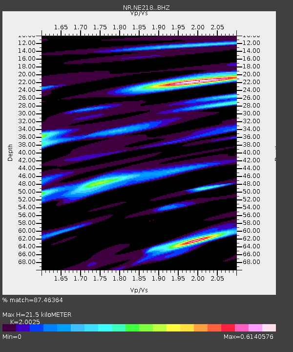
| Estimated Moho Depth: |
21.5 km |
| Estimated Crust Vp/Vs: |
2.00 |
| Assumed Crust Vp: |
6.459 km/s |
| Estimated Crust Vs: |
3.226 km/s |
| Estimated Crust Poisson's Ratio: |
0.33 |
|
| Radial Match: |
87.46364 % |
| Radial Bump: |
400 |
| Transverse Match: |
66.40091 % |
| Transverse Bump: |
400 |
| SOD ConfigId: |
11737051 |
| Insert Time: |
2019-04-26 19:31:07.995 +0000 |
| GWidth: |
2.5 |
| Max Bumps: |
400 |
| Tol: |
0.001 |
|

Signal To Noise
| Channel | StoN | STA | LTA |
| NR:NE218: :BHZ:20170221T14:19:59.441982Z | 6.9827685 | 1.7606066E-6 | 2.521359E-7 |
| NR:NE218: :BHN:20170221T14:19:59.441982Z | 1.9916453 | 4.9869067E-7 | 2.5039128E-7 |
| NR:NE218: :BHE:20170221T14:19:59.441982Z | 2.706703 | 8.66456E-7 | 3.2011494E-7 |
| Arrivals |
| Ps | 3.4 SECOND |
| PpPs | 9.8 SECOND |
| PsPs/PpSs | 13 SECOND |


