You are here: Home > Network List > CI - Caltech Regional Seismic Network Stations List
> Station RPV Rancho Palos Verdes, California, USA > Earthquake Result Viewer
RPV Rancho Palos Verdes, California, USA - Earthquake Result Viewer
| Earthquake location: |
South Of Fiji Islands |
| Earthquake latitude/longitude: |
-23.6/178.5 |
| Earthquake time(UTC): |
2002/08/19 (231) 11:03:13 GMT |
| Earthquake Depth: |
650 km |
| Earthquake Magnitude: |
5.9 MB |
| Earthquake Catalog/Contributor: |
WHDF/NEIC |
|
| Network: |
CI Caltech Regional Seismic Network |
| Station: |
RPV Rancho Palos Verdes, California, USA |
| Lat/Lon: |
33.74 N/118.40 W |
| Elevation: |
64 m |
|
| Distance: |
82.7 deg |
| Az: |
48.488 deg |
| Baz: |
235.547 deg |
| Ray Param: |
0.044685736 |
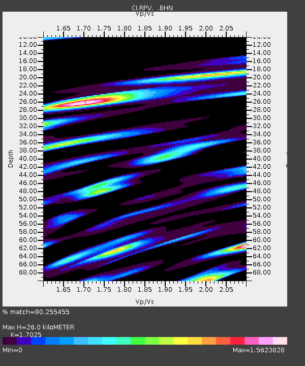
| Estimated Moho Depth: |
26.0 km |
| Estimated Crust Vp/Vs: |
1.70 |
| Assumed Crust Vp: |
6.048 km/s |
| Estimated Crust Vs: |
3.552 km/s |
| Estimated Crust Poisson's Ratio: |
0.24 |
|
| Radial Match: |
90.255455 % |
| Radial Bump: |
400 |
| Transverse Match: |
90.36674 % |
| Transverse Bump: |
400 |
| SOD ConfigId: |
3770 |
| Insert Time: |
2010-03-05 22:07:56.456 +0000 |
| GWidth: |
2.5 |
| Max Bumps: |
400 |
| Tol: |
0.001 |
|

Signal To Noise
| Channel | StoN | STA | LTA |
| CI:RPV: :BHN:20020819T11:13:59.823018Z | 0.7906301 | 1.9706172E-7 | 2.4924643E-7 |
| CI:RPV: :BHE:20020819T11:13:59.823018Z | 0.61338484 | 2.0272905E-7 | 3.3050873E-7 |
| CI:RPV: :BHZ:20020819T11:13:59.823018Z | 0.7237569 | 1.428713E-7 | 1.9740233E-7 |
| Arrivals |
| Ps | 3.1 SECOND |
| PpPs | 11 SECOND |
| PsPs/PpSs | 14 SECOND |


