You are here: Home > Network List > PE - Penn State Network Stations List
> Station PAPL Promised Land State Park, Greentown, PA > Earthquake Result Viewer
PAPL Promised Land State Park, Greentown, PA - Earthquake Result Viewer
| Earthquake location: |
Southern Bolivia |
| Earthquake latitude/longitude: |
-19.3/-63.9 |
| Earthquake time(UTC): |
2017/02/21 (052) 14:09:04 GMT |
| Earthquake Depth: |
598 km |
| Earthquake Magnitude: |
6.5 Mww |
| Earthquake Catalog/Contributor: |
NEIC PDE/us |
|
| Network: |
PE Penn State Network |
| Station: |
PAPL Promised Land State Park, Greentown, PA |
| Lat/Lon: |
41.30 N/75.02 W |
| Elevation: |
572 m |
|
| Distance: |
61.2 deg |
| Az: |
350.448 deg |
| Baz: |
167.993 deg |
| Ray Param: |
0.05870851 |
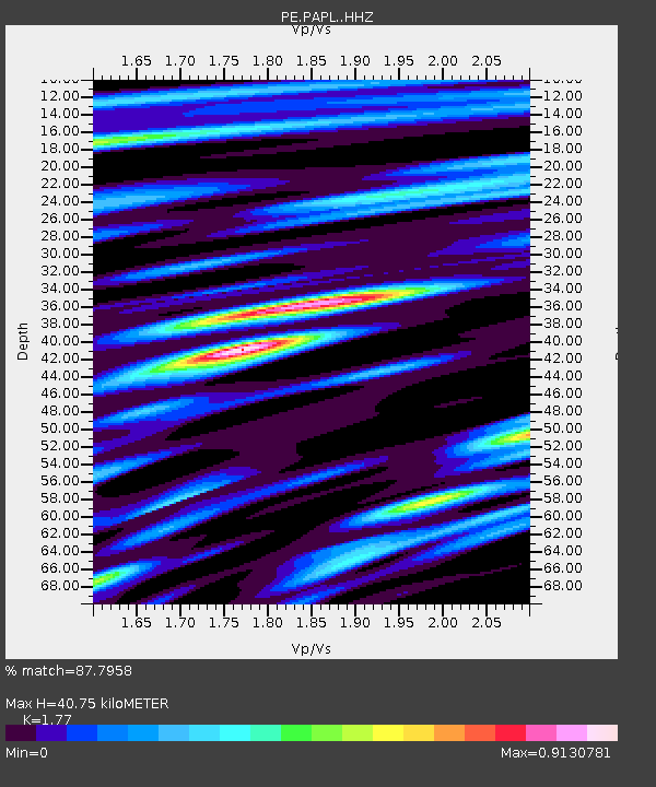
| Estimated Moho Depth: |
40.75 km |
| Estimated Crust Vp/Vs: |
1.77 |
| Assumed Crust Vp: |
6.283 km/s |
| Estimated Crust Vs: |
3.55 km/s |
| Estimated Crust Poisson's Ratio: |
0.27 |
|
| Radial Match: |
87.7958 % |
| Radial Bump: |
359 |
| Transverse Match: |
73.40339 % |
| Transverse Bump: |
400 |
| SOD ConfigId: |
11737051 |
| Insert Time: |
2019-04-26 19:32:22.953 +0000 |
| GWidth: |
2.5 |
| Max Bumps: |
400 |
| Tol: |
0.001 |
|

Signal To Noise
| Channel | StoN | STA | LTA |
| PE:PAPL: :HHZ:20170221T14:17:51.27499Z | 6.250563 | 1.6818159E-6 | 2.6906628E-7 |
| PE:PAPL: :HHN:20170221T14:17:51.27499Z | 3.6192148 | 7.082253E-7 | 1.9568478E-7 |
| PE:PAPL: :HHE:20170221T14:17:51.27499Z | 0.40495932 | 1.8859211E-7 | 4.657063E-7 |
| Arrivals |
| Ps | 5.2 SECOND |
| PpPs | 17 SECOND |
| PsPs/PpSs | 22 SECOND |


