You are here: Home > Network List > PE - Penn State Network Stations List
> Station PSUB Penn State - Brandywine Campus > Earthquake Result Viewer
PSUB Penn State - Brandywine Campus - Earthquake Result Viewer
| Earthquake location: |
Southern Bolivia |
| Earthquake latitude/longitude: |
-19.3/-63.9 |
| Earthquake time(UTC): |
2017/02/21 (052) 14:09:04 GMT |
| Earthquake Depth: |
598 km |
| Earthquake Magnitude: |
6.5 Mww |
| Earthquake Catalog/Contributor: |
NEIC PDE/us |
|
| Network: |
PE Penn State Network |
| Station: |
PSUB Penn State - Brandywine Campus |
| Lat/Lon: |
39.93 N/75.45 W |
| Elevation: |
110 m |
|
| Distance: |
59.9 deg |
| Az: |
349.745 deg |
| Baz: |
167.368 deg |
| Ray Param: |
0.05948917 |
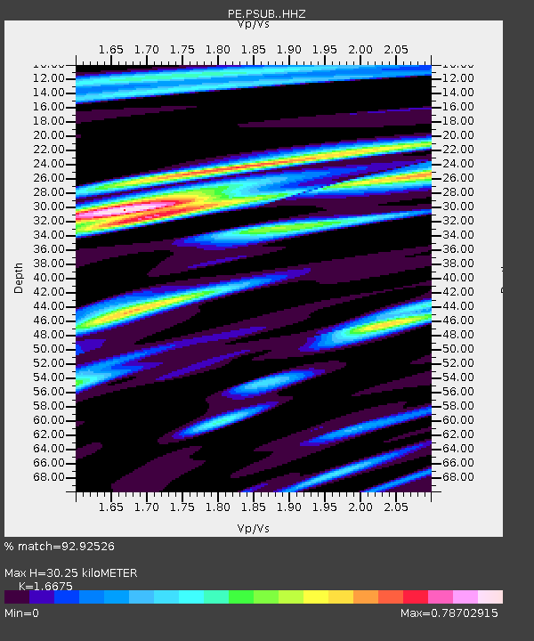
| Estimated Moho Depth: |
30.25 km |
| Estimated Crust Vp/Vs: |
1.67 |
| Assumed Crust Vp: |
6.287 km/s |
| Estimated Crust Vs: |
3.771 km/s |
| Estimated Crust Poisson's Ratio: |
0.22 |
|
| Radial Match: |
92.92526 % |
| Radial Bump: |
372 |
| Transverse Match: |
74.9298 % |
| Transverse Bump: |
400 |
| SOD ConfigId: |
11737051 |
| Insert Time: |
2019-04-26 19:32:30.532 +0000 |
| GWidth: |
2.5 |
| Max Bumps: |
400 |
| Tol: |
0.001 |
|
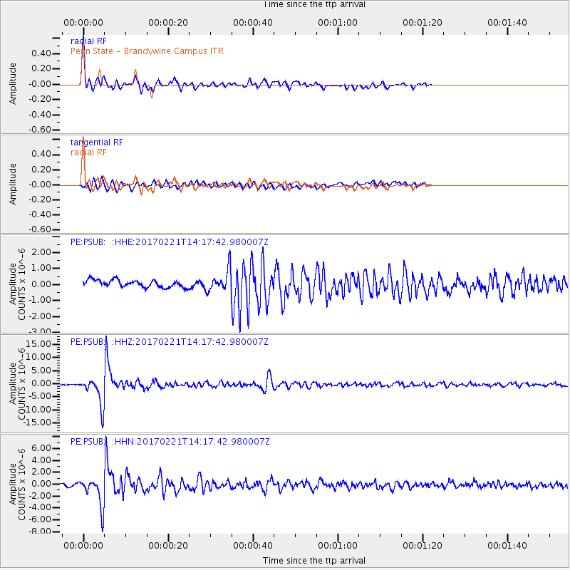
Signal To Noise
| Channel | StoN | STA | LTA |
| PE:PSUB: :HHZ:20170221T14:17:42.980007Z | 35.756577 | 5.526377E-6 | 1.5455554E-7 |
| PE:PSUB: :HHN:20170221T14:17:42.980007Z | 15.983195 | 2.5413522E-6 | 1.5900152E-7 |
| PE:PSUB: :HHE:20170221T14:17:42.980007Z | 3.1452222 | 6.9792446E-7 | 2.218999E-7 |
| Arrivals |
| Ps | 3.4 SECOND |
| PpPs | 12 SECOND |
| PsPs/PpSs | 16 SECOND |


