You are here: Home > Network List > RV - Regional Alberta Seismic Observatory for Earthquake Studies Network Stations List
> Station KIMIA Kimiwan Lookout Tower, AB > Earthquake Result Viewer
KIMIA Kimiwan Lookout Tower, AB - Earthquake Result Viewer
| Earthquake location: |
Southern Bolivia |
| Earthquake latitude/longitude: |
-19.3/-63.9 |
| Earthquake time(UTC): |
2017/02/21 (052) 14:09:04 GMT |
| Earthquake Depth: |
598 km |
| Earthquake Magnitude: |
6.5 Mww |
| Earthquake Catalog/Contributor: |
NEIC PDE/us |
|
| Network: |
RV Regional Alberta Seismic Observatory for Earthquake Studies Network |
| Station: |
KIMIA Kimiwan Lookout Tower, AB |
| Lat/Lon: |
55.99 N/116.61 W |
| Elevation: |
764 m |
|
| Distance: |
87.1 deg |
| Az: |
333.413 deg |
| Baz: |
131.2 deg |
| Ray Param: |
0.041829478 |
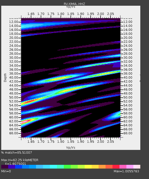
| Estimated Moho Depth: |
62.25 km |
| Estimated Crust Vp/Vs: |
1.61 |
| Assumed Crust Vp: |
6.426 km/s |
| Estimated Crust Vs: |
3.998 km/s |
| Estimated Crust Poisson's Ratio: |
0.18 |
|
| Radial Match: |
85.51007 % |
| Radial Bump: |
360 |
| Transverse Match: |
75.98835 % |
| Transverse Bump: |
334 |
| SOD ConfigId: |
11737051 |
| Insert Time: |
2019-04-26 19:33:11.220 +0000 |
| GWidth: |
2.5 |
| Max Bumps: |
400 |
| Tol: |
0.001 |
|

Signal To Noise
| Channel | StoN | STA | LTA |
| RV:KIMIA: :HHZ:20170221T14:20:16.67001Z | 31.655256 | 4.0122545E-6 | 1.2674845E-7 |
| RV:KIMIA: :HHN:20170221T14:20:16.67001Z | 1.9871869 | 5.9600904E-7 | 2.99926E-7 |
| RV:KIMIA: :HHE:20170221T14:20:16.67001Z | 1.8890008 | 6.815701E-7 | 3.6080985E-7 |
| Arrivals |
| Ps | 6.0 SECOND |
| PpPs | 25 SECOND |
| PsPs/PpSs | 31 SECOND |


