You are here: Home > Network List > TA - USArray Transportable Network (new EarthScope stations) Stations List
> Station 435B Jarrell, TX, USA > Earthquake Result Viewer
435B Jarrell, TX, USA - Earthquake Result Viewer

| Earthquake location: |
Southern Bolivia |
| Earthquake latitude/longitude: |
-19.3/-63.9 |
| Earthquake time(UTC): |
2017/02/21 (052) 14:09:04 GMT |
| Earthquake Depth: |
598 km |
| Earthquake Magnitude: |
6.5 Mww |
| Earthquake Catalog/Contributor: |
NEIC PDE/us |
|
| Network: |
TA USArray Transportable Network (new EarthScope stations) |
| Station: |
435B Jarrell, TX, USA |
| Lat/Lon: |
30.78 N/97.58 W |
| Elevation: |
248 m |
|
| Distance: |
59.4 deg |
| Az: |
326.314 deg |
| Baz: |
142.501 deg |
| Ray Param: |
0.059792124 |
| Estimated Moho Depth: |
12.5 km |
| Estimated Crust Vp/Vs: |
1.86 |
| Assumed Crust Vp: |
6.347 km/s |
| Estimated Crust Vs: |
3.417 km/s |
| Estimated Crust Poisson's Ratio: |
0.30 |
|
| Radial Match: |
81.402374 % |
| Radial Bump: |
400 |
| Transverse Match: |
65.99017 % |
| Transverse Bump: |
400 |
| SOD ConfigId: |
11737051 |
| Insert Time: |
2019-04-26 19:33:36.963 +0000 |
| GWidth: |
2.5 |
| Max Bumps: |
400 |
| Tol: |
0.001 |
|
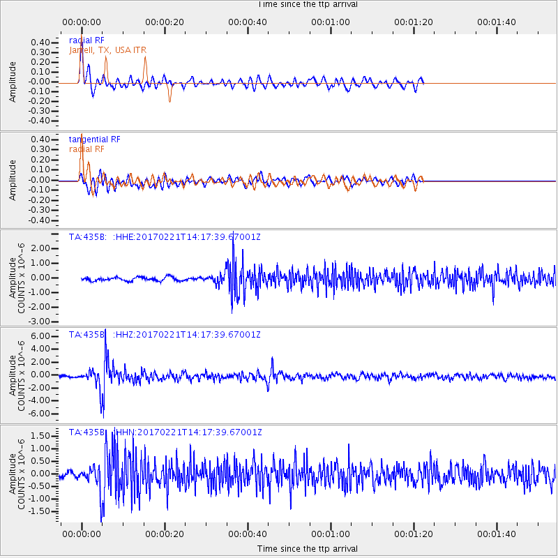
Signal To Noise
| Channel | StoN | STA | LTA |
| TA:435B: :HHZ:20170221T14:17:39.67001Z | 7.106443 | 1.4661123E-6 | 2.0630748E-7 |
| TA:435B: :HHN:20170221T14:17:39.67001Z | 6.642294 | 4.8151736E-7 | 7.2492625E-8 |
| TA:435B: :HHE:20170221T14:17:39.67001Z | 2.5160098 | 3.186363E-7 | 1.266435E-7 |
| Arrivals |
| Ps | 1.8 SECOND |
| PpPs | 5.4 SECOND |
| PsPs/PpSs | 7.2 SECOND |


