You are here: Home > Network List > TA - USArray Transportable Network (new EarthScope stations) Stations List
> Station KSCO Kaye Shedlock's, Cheyenne Wells, CO, USA > Earthquake Result Viewer
KSCO Kaye Shedlock's, Cheyenne Wells, CO, USA - Earthquake Result Viewer
| Earthquake location: |
Southern Bolivia |
| Earthquake latitude/longitude: |
-19.3/-63.9 |
| Earthquake time(UTC): |
2017/02/21 (052) 14:09:04 GMT |
| Earthquake Depth: |
598 km |
| Earthquake Magnitude: |
6.5 Mww |
| Earthquake Catalog/Contributor: |
NEIC PDE/us |
|
| Network: |
TA USArray Transportable Network (new EarthScope stations) |
| Station: |
KSCO Kaye Shedlock's, Cheyenne Wells, CO, USA |
| Lat/Lon: |
39.01 N/102.63 W |
| Elevation: |
1382 m |
|
| Distance: |
68.4 deg |
| Az: |
328.381 deg |
| Baz: |
140.533 deg |
| Ray Param: |
0.05420353 |
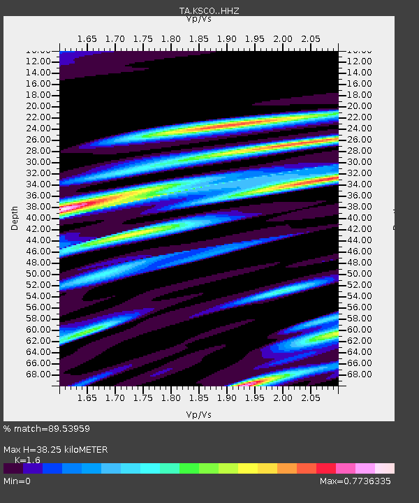
| Estimated Moho Depth: |
38.25 km |
| Estimated Crust Vp/Vs: |
1.60 |
| Assumed Crust Vp: |
6.242 km/s |
| Estimated Crust Vs: |
3.901 km/s |
| Estimated Crust Poisson's Ratio: |
0.18 |
|
| Radial Match: |
89.53959 % |
| Radial Bump: |
358 |
| Transverse Match: |
69.79275 % |
| Transverse Bump: |
368 |
| SOD ConfigId: |
11737051 |
| Insert Time: |
2019-04-26 19:33:41.005 +0000 |
| GWidth: |
2.5 |
| Max Bumps: |
400 |
| Tol: |
0.001 |
|

Signal To Noise
| Channel | StoN | STA | LTA |
| TA:KSCO: :HHZ:20170221T14:18:36.560024Z | 9.11235 | 7.8525846E-7 | 8.617519E-8 |
| TA:KSCO: :HHN:20170221T14:18:36.560024Z | 0.76262736 | 2.2291356E-7 | 2.9229682E-7 |
| TA:KSCO: :HHE:20170221T14:18:36.560024Z | 1.7460997 | 3.384818E-7 | 1.9385021E-7 |
| Arrivals |
| Ps | 3.8 SECOND |
| PpPs | 15 SECOND |
| PsPs/PpSs | 19 SECOND |


