You are here: Home > Network List > TA - USArray Transportable Network (new EarthScope stations) Stations List
> Station O20A White River City, CO, USA > Earthquake Result Viewer
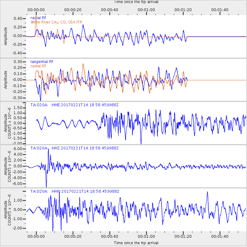
O20A White River City, CO, USA - Earthquake Result Viewer
*The percent match for this event was below the threshold and hence no stack was calculated.
| Earthquake location: |
Southern Bolivia |
| Earthquake latitude/longitude: |
-19.3/-63.9 |
| Earthquake time(UTC): |
2017/02/21 (052) 14:09:04 GMT |
| Earthquake Depth: |
598 km |
| Earthquake Magnitude: |
6.5 Mww |
| Earthquake Catalog/Contributor: |
NEIC PDE/us |
|
| Network: |
TA USArray Transportable Network (new EarthScope stations) |
| Station: |
O20A White River City, CO, USA |
| Lat/Lon: |
40.13 N/108.24 W |
| Elevation: |
1915 m |
|
| Distance: |
72.1 deg |
| Az: |
325.732 deg |
| Baz: |
136.073 deg |
| Ray Param: |
$rayparam |
*The percent match for this event was below the threshold and hence was not used in the summary stack. |
|
| Radial Match: |
67.55782 % |
| Radial Bump: |
393 |
| Transverse Match: |
63.624664 % |
| Transverse Bump: |
400 |
| SOD ConfigId: |
11737051 |
| Insert Time: |
2019-04-26 19:33:48.017 +0000 |
| GWidth: |
2.5 |
| Max Bumps: |
400 |
| Tol: |
0.001 |
|
Signal To Noise
| Channel | StoN | STA | LTA |
| TA:O20A: :HHZ:20170221T14:18:58.459988Z | 2.2388773 | 4.913512E-7 | 2.1946323E-7 |
| TA:O20A: :HHN:20170221T14:18:58.459988Z | 1.0194207 | 2.5621026E-7 | 2.5132923E-7 |
| TA:O20A: :HHE:20170221T14:18:58.459988Z | 1.0701079 | 2.829809E-7 | 2.6444144E-7 |
| Arrivals |
| Ps | |
| PpPs | |
| PsPs/PpSs | |


