You are here: Home > Network List > TA - USArray Transportable Network (new EarthScope stations) Stations List
> Station SFIN Lafayette, IN, USA > Earthquake Result Viewer
SFIN Lafayette, IN, USA - Earthquake Result Viewer
| Earthquake location: |
Southern Bolivia |
| Earthquake latitude/longitude: |
-19.3/-63.9 |
| Earthquake time(UTC): |
2017/02/21 (052) 14:09:04 GMT |
| Earthquake Depth: |
598 km |
| Earthquake Magnitude: |
6.5 Mww |
| Earthquake Catalog/Contributor: |
NEIC PDE/us |
|
| Network: |
TA USArray Transportable Network (new EarthScope stations) |
| Station: |
SFIN Lafayette, IN, USA |
| Lat/Lon: |
40.38 N/87.10 W |
| Elevation: |
165 m |
|
| Distance: |
63.2 deg |
| Az: |
340.292 deg |
| Baz: |
155.356 deg |
| Ray Param: |
0.0574584 |
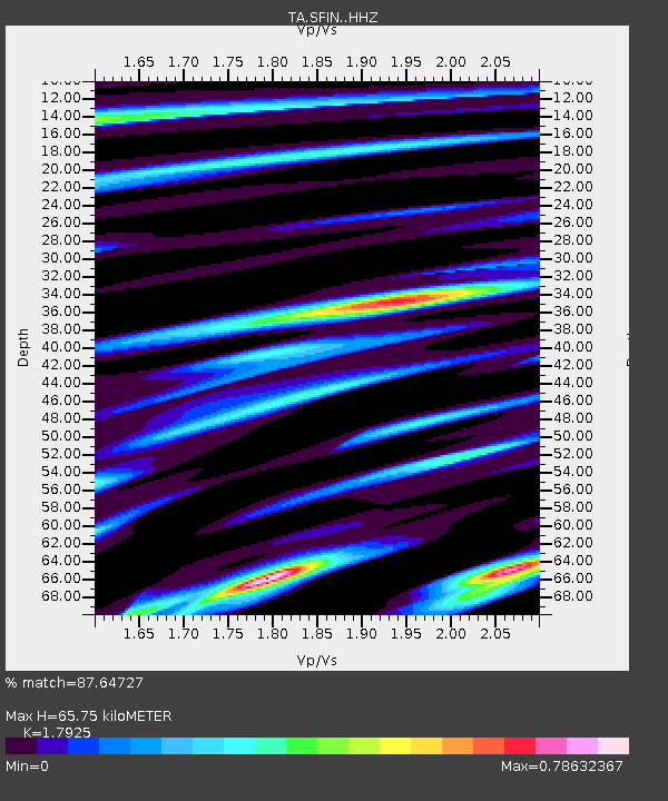
| Estimated Moho Depth: |
65.75 km |
| Estimated Crust Vp/Vs: |
1.79 |
| Assumed Crust Vp: |
6.498 km/s |
| Estimated Crust Vs: |
3.625 km/s |
| Estimated Crust Poisson's Ratio: |
0.27 |
|
| Radial Match: |
87.64727 % |
| Radial Bump: |
350 |
| Transverse Match: |
66.61058 % |
| Transverse Bump: |
400 |
| SOD ConfigId: |
11737051 |
| Insert Time: |
2019-04-26 19:33:53.818 +0000 |
| GWidth: |
2.5 |
| Max Bumps: |
400 |
| Tol: |
0.001 |
|
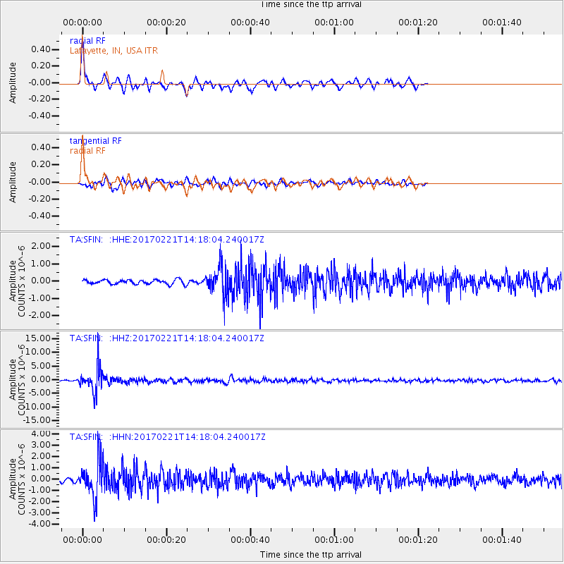
Signal To Noise
| Channel | StoN | STA | LTA |
| TA:SFIN: :HHZ:20170221T14:18:04.240017Z | 21.596128 | 4.746336E-6 | 2.1977716E-7 |
| TA:SFIN: :HHN:20170221T14:18:04.240017Z | 10.346177 | 1.6555224E-6 | 1.6001295E-7 |
| TA:SFIN: :HHE:20170221T14:18:04.240017Z | 6.514254 | 8.213268E-7 | 1.2608147E-7 |
| Arrivals |
| Ps | 8.4 SECOND |
| PpPs | 27 SECOND |
| PsPs/PpSs | 35 SECOND |


