You are here: Home > Network List > TA - USArray Transportable Network (new EarthScope stations) Stations List
> Station TIGA Tifton, GA, USA > Earthquake Result Viewer
TIGA Tifton, GA, USA - Earthquake Result Viewer

| Earthquake location: |
Southern Bolivia |
| Earthquake latitude/longitude: |
-19.3/-63.9 |
| Earthquake time(UTC): |
2017/02/21 (052) 14:09:04 GMT |
| Earthquake Depth: |
598 km |
| Earthquake Magnitude: |
6.5 Mww |
| Earthquake Catalog/Contributor: |
NEIC PDE/us |
|
| Network: |
TA USArray Transportable Network (new EarthScope stations) |
| Station: |
TIGA Tifton, GA, USA |
| Lat/Lon: |
31.44 N/83.59 W |
| Elevation: |
109 m |
|
| Distance: |
53.9 deg |
| Az: |
339.107 deg |
| Baz: |
156.789 deg |
| Ray Param: |
0.06319033 |
| Estimated Moho Depth: |
21.0 km |
| Estimated Crust Vp/Vs: |
1.62 |
| Assumed Crust Vp: |
6.565 km/s |
| Estimated Crust Vs: |
4.065 km/s |
| Estimated Crust Poisson's Ratio: |
0.19 |
|
| Radial Match: |
82.4988 % |
| Radial Bump: |
395 |
| Transverse Match: |
71.22627 % |
| Transverse Bump: |
400 |
| SOD ConfigId: |
11737051 |
| Insert Time: |
2019-04-26 19:33:59.335 +0000 |
| GWidth: |
2.5 |
| Max Bumps: |
400 |
| Tol: |
0.001 |
|
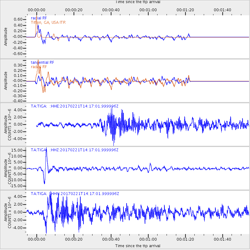
Signal To Noise
| Channel | StoN | STA | LTA |
| TA:TIGA: :HHZ:20170221T14:17:01.999996Z | 16.11409 | 4.4251233E-6 | 2.7461206E-7 |
| TA:TIGA: :HHN:20170221T14:17:01.999996Z | 3.5808718 | 9.170658E-7 | 2.5610126E-7 |
| TA:TIGA: :HHE:20170221T14:17:01.999996Z | 2.0922444 | 6.710976E-7 | 3.2075488E-7 |
| Arrivals |
| Ps | 2.1 SECOND |
| PpPs | 7.9 SECOND |
| PsPs/PpSs | 10.0 SECOND |


