You are here: Home > Network List > CI - Caltech Regional Seismic Network Stations List
> Station RPV Rancho Palos Verdes, California, USA > Earthquake Result Viewer
RPV Rancho Palos Verdes, California, USA - Earthquake Result Viewer
| Earthquake location: |
Kamchatka Peninsula, Russia |
| Earthquake latitude/longitude: |
55.5/160.0 |
| Earthquake time(UTC): |
2003/06/16 (167) 22:08:02 GMT |
| Earthquake Depth: |
175 km |
| Earthquake Magnitude: |
6.3 MB, 6.9 MW, 6.9 MW |
| Earthquake Catalog/Contributor: |
WHDF/NEIC |
|
| Network: |
CI Caltech Regional Seismic Network |
| Station: |
RPV Rancho Palos Verdes, California, USA |
| Lat/Lon: |
33.74 N/118.40 W |
| Elevation: |
64 m |
|
| Distance: |
58.4 deg |
| Az: |
75.412 deg |
| Baz: |
318.626 deg |
| Ray Param: |
0.062305618 |
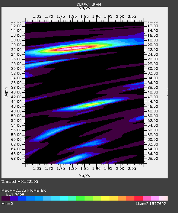
| Estimated Moho Depth: |
21.25 km |
| Estimated Crust Vp/Vs: |
1.79 |
| Assumed Crust Vp: |
6.048 km/s |
| Estimated Crust Vs: |
3.374 km/s |
| Estimated Crust Poisson's Ratio: |
0.27 |
|
| Radial Match: |
91.22105 % |
| Radial Bump: |
364 |
| Transverse Match: |
88.69723 % |
| Transverse Bump: |
400 |
| SOD ConfigId: |
3787 |
| Insert Time: |
2010-03-05 22:08:32.025 +0000 |
| GWidth: |
2.5 |
| Max Bumps: |
400 |
| Tol: |
0.001 |
|

Signal To Noise
| Channel | StoN | STA | LTA |
| CI:RPV: :BHN:20030616T22:17:08.598008Z | 0.99805725 | 7.015218E-7 | 7.028873E-7 |
| CI:RPV: :BHE:20030616T22:17:08.598008Z | 1.0369456 | 7.3589797E-7 | 7.096785E-7 |
| CI:RPV: :BHZ:20030616T22:17:08.598008Z | 2.9030728 | 2.2834975E-6 | 7.8657945E-7 |
| Arrivals |
| Ps | 2.9 SECOND |
| PpPs | 9.4 SECOND |
| PsPs/PpSs | 12 SECOND |


