You are here: Home > Network List > TA - USArray Transportable Network (new EarthScope stations) Stations List
> Station G23K Bananza Creek, AK, USA > Earthquake Result Viewer
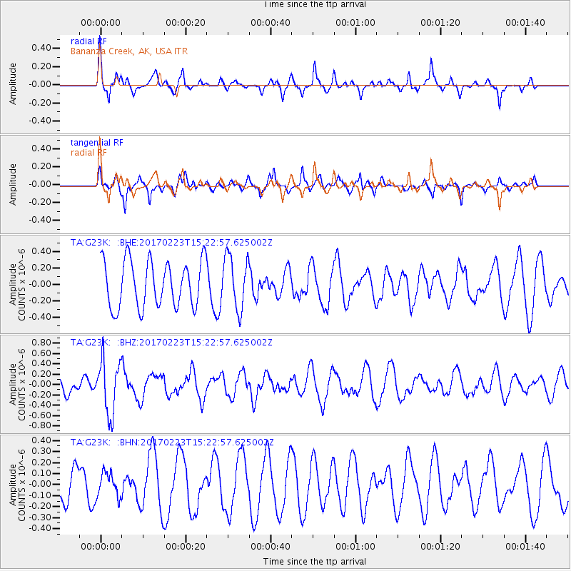
G23K Bananza Creek, AK, USA - Earthquake Result Viewer
*The percent match for this event was below the threshold and hence no stack was calculated.
| Earthquake location: |
Eastern New Guinea Reg., P.N.G. |
| Earthquake latitude/longitude: |
-5.9/146.7 |
| Earthquake time(UTC): |
2017/02/23 (054) 15:11:05 GMT |
| Earthquake Depth: |
116 km |
| Earthquake Magnitude: |
5.4 Mww |
| Earthquake Catalog/Contributor: |
NEIC PDE/us |
|
| Network: |
TA USArray Transportable Network (new EarthScope stations) |
| Station: |
G23K Bananza Creek, AK, USA |
| Lat/Lon: |
66.71 N/150.02 W |
| Elevation: |
746 m |
|
| Distance: |
85.1 deg |
| Az: |
20.874 deg |
| Baz: |
243.06 deg |
| Ray Param: |
$rayparam |
*The percent match for this event was below the threshold and hence was not used in the summary stack. |
|
| Radial Match: |
68.19794 % |
| Radial Bump: |
400 |
| Transverse Match: |
58.050415 % |
| Transverse Bump: |
400 |
| SOD ConfigId: |
11737051 |
| Insert Time: |
2019-04-26 19:40:35.456 +0000 |
| GWidth: |
2.5 |
| Max Bumps: |
400 |
| Tol: |
0.001 |
|
Signal To Noise
| Channel | StoN | STA | LTA |
| TA:G23K: :BHZ:20170223T15:22:57.625002Z | 3.0727727 | 5.254089E-7 | 1.7098853E-7 |
| TA:G23K: :BHN:20170223T15:22:57.625002Z | 0.9106893 | 1.08222416E-7 | 1.18835715E-7 |
| TA:G23K: :BHE:20170223T15:22:57.625002Z | 1.1691387 | 3.2891484E-7 | 2.813309E-7 |
| Arrivals |
| Ps | |
| PpPs | |
| PsPs/PpSs | |


