You are here: Home > Network List > CI - Caltech Regional Seismic Network Stations List
> Station RPV Rancho Palos Verdes, California, USA > Earthquake Result Viewer
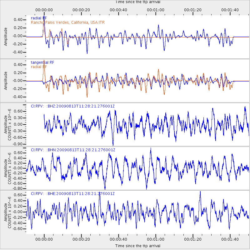
RPV Rancho Palos Verdes, California, USA - Earthquake Result Viewer
*The percent match for this event was below the threshold and hence no stack was calculated.
| Earthquake location: |
Tonga Islands |
| Earthquake latitude/longitude: |
-21.7/-174.6 |
| Earthquake time(UTC): |
2009/08/13 (225) 11:17:01 GMT |
| Earthquake Depth: |
10 km |
| Earthquake Magnitude: |
5.6 MW, 5.3 MB |
| Earthquake Catalog/Contributor: |
WHDF/NEIC |
|
| Network: |
CI Caltech Regional Seismic Network |
| Station: |
RPV Rancho Palos Verdes, California, USA |
| Lat/Lon: |
33.74 N/118.40 W |
| Elevation: |
64 m |
|
| Distance: |
76.8 deg |
| Az: |
45.312 deg |
| Baz: |
232.531 deg |
| Ray Param: |
$rayparam |
*The percent match for this event was below the threshold and hence was not used in the summary stack. |
|
| Radial Match: |
66.50415 % |
| Radial Bump: |
400 |
| Transverse Match: |
53.965263 % |
| Transverse Bump: |
400 |
| SOD ConfigId: |
2622 |
| Insert Time: |
2010-03-05 22:09:20.267 +0000 |
| GWidth: |
2.5 |
| Max Bumps: |
400 |
| Tol: |
0.001 |
|
Signal To Noise
| Channel | StoN | STA | LTA |
| CI:RPV: :BHN:20090813T11:28:21.276001Z | 2.3570235 | 3.1649765E-7 | 1.3427852E-7 |
| CI:RPV: :BHE:20090813T11:28:21.276001Z | 0.6636165 | 1.511842E-7 | 2.2781862E-7 |
| CI:RPV: :BHZ:20090813T11:28:21.276001Z | 1.4377676 | 3.1702004E-7 | 2.2049464E-7 |
| Arrivals |
| Ps | |
| PpPs | |
| PsPs/PpSs | |


