You are here: Home > Network List > TA - USArray Transportable Network (new EarthScope stations) Stations List
> Station J26L Joseph Creek, AK, USA > Earthquake Result Viewer
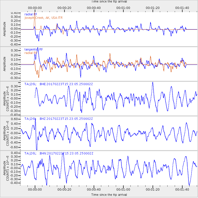
J26L Joseph Creek, AK, USA - Earthquake Result Viewer
*The percent match for this event was below the threshold and hence no stack was calculated.
| Earthquake location: |
Eastern New Guinea Reg., P.N.G. |
| Earthquake latitude/longitude: |
-5.9/146.7 |
| Earthquake time(UTC): |
2017/02/23 (054) 15:11:05 GMT |
| Earthquake Depth: |
116 km |
| Earthquake Magnitude: |
5.4 Mww |
| Earthquake Catalog/Contributor: |
NEIC PDE/us |
|
| Network: |
TA USArray Transportable Network (new EarthScope stations) |
| Station: |
J26L Joseph Creek, AK, USA |
| Lat/Lon: |
64.50 N/143.56 W |
| Elevation: |
1144 m |
|
| Distance: |
86.7 deg |
| Az: |
23.994 deg |
| Baz: |
249.161 deg |
| Ray Param: |
$rayparam |
*The percent match for this event was below the threshold and hence was not used in the summary stack. |
|
| Radial Match: |
63.23259 % |
| Radial Bump: |
400 |
| Transverse Match: |
55.814354 % |
| Transverse Bump: |
400 |
| SOD ConfigId: |
11737051 |
| Insert Time: |
2019-04-26 19:40:41.239 +0000 |
| GWidth: |
2.5 |
| Max Bumps: |
400 |
| Tol: |
0.001 |
|
Signal To Noise
| Channel | StoN | STA | LTA |
| TA:J26L: :BHZ:20170223T15:23:05.250002Z | 3.001304 | 3.3870032E-7 | 1.12851055E-7 |
| TA:J26L: :BHN:20170223T15:23:05.250002Z | 1.7326654 | 1.779584E-7 | 1.0270788E-7 |
| TA:J26L: :BHE:20170223T15:23:05.250002Z | 1.2614876 | 1.5259883E-7 | 1.2096737E-7 |
| Arrivals |
| Ps | |
| PpPs | |
| PsPs/PpSs | |


