You are here: Home > Network List > TA - USArray Transportable Network (new EarthScope stations) Stations List
> Station N23A Red Feather Lakes, CO, USA > Earthquake Result Viewer
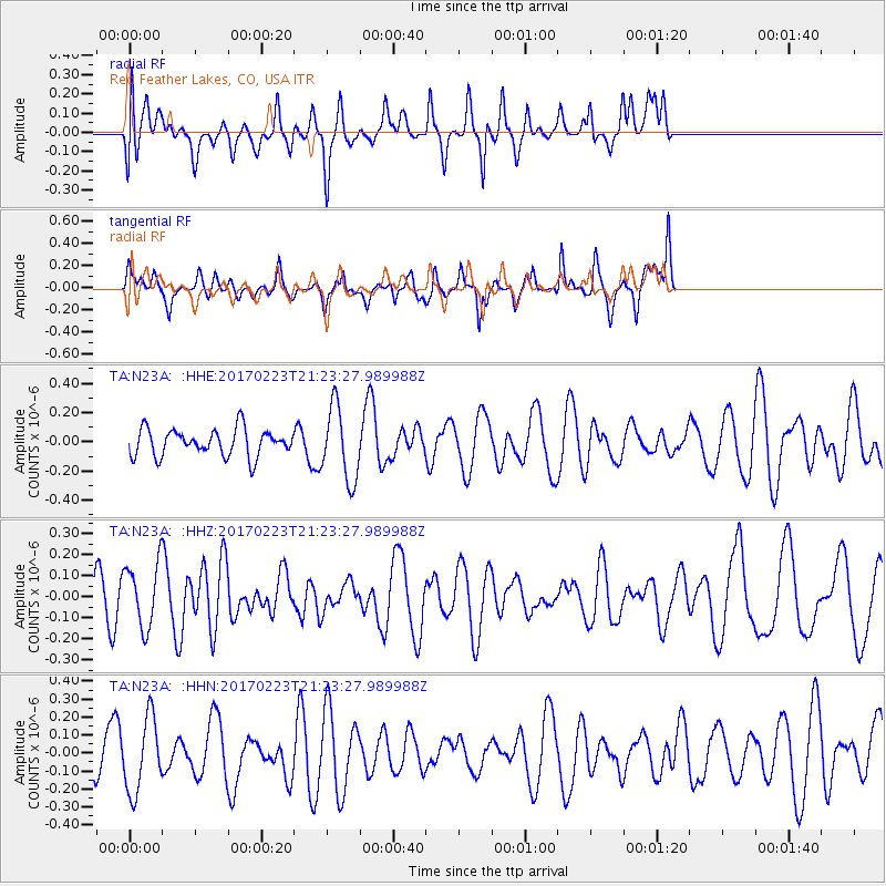
N23A Red Feather Lakes, CO, USA - Earthquake Result Viewer
*The percent match for this event was below the threshold and hence no stack was calculated.
| Earthquake location: |
Vanuatu Islands Region |
| Earthquake latitude/longitude: |
-21.3/174.4 |
| Earthquake time(UTC): |
2017/02/23 (054) 21:10:31 GMT |
| Earthquake Depth: |
10 km |
| Earthquake Magnitude: |
5.5 mb |
| Earthquake Catalog/Contributor: |
NEIC PDE/us |
|
| Network: |
TA USArray Transportable Network (new EarthScope stations) |
| Station: |
N23A Red Feather Lakes, CO, USA |
| Lat/Lon: |
40.89 N/105.94 W |
| Elevation: |
2458 m |
|
| Distance: |
96.2 deg |
| Az: |
48.611 deg |
| Baz: |
247.374 deg |
| Ray Param: |
$rayparam |
*The percent match for this event was below the threshold and hence was not used in the summary stack. |
|
| Radial Match: |
51.510014 % |
| Radial Bump: |
400 |
| Transverse Match: |
51.44383 % |
| Transverse Bump: |
400 |
| SOD ConfigId: |
11737051 |
| Insert Time: |
2019-04-26 19:46:14.101 +0000 |
| GWidth: |
2.5 |
| Max Bumps: |
400 |
| Tol: |
0.001 |
|
Signal To Noise
| Channel | StoN | STA | LTA |
| TA:N23A: :HHZ:20170223T21:23:27.989988Z | 1.0060607 | 1.4861213E-7 | 1.4771688E-7 |
| TA:N23A: :HHN:20170223T21:23:27.989988Z | 1.0128478 | 2.0889925E-7 | 2.062494E-7 |
| TA:N23A: :HHE:20170223T21:23:27.989988Z | 2.7384038 | 2.5253624E-7 | 9.222023E-8 |
| Arrivals |
| Ps | |
| PpPs | |
| PsPs/PpSs | |


