You are here: Home > Network List > GS - US Geological Survey Networks Stations List
> Station KAN10 Keim Farm, Anthony, KS, USA > Earthquake Result Viewer
KAN10 Keim Farm, Anthony, KS, USA - Earthquake Result Viewer
*The percent match for this event was below the threshold and hence no stack was calculated.
| Earthquake location: |
Santiago Del Estero Prov., Arg. |
| Earthquake latitude/longitude: |
-29.9/-64.5 |
| Earthquake time(UTC): |
2015/11/13 (317) 06:04:15 GMT |
| Earthquake Depth: |
11 km |
| Earthquake Magnitude: |
5.8 MWP |
| Earthquake Catalog/Contributor: |
NEIC PDE/NEIC COMCAT |
|
| Network: |
GS US Geological Survey Networks |
| Station: |
KAN10 Keim Farm, Anthony, KS, USA |
| Lat/Lon: |
37.12 N/98.10 W |
| Elevation: |
417 m |
|
| Distance: |
73.7 deg |
| Az: |
332.563 deg |
| Baz: |
149.951 deg |
| Ray Param: |
$rayparam |
*The percent match for this event was below the threshold and hence was not used in the summary stack. |
|
| Radial Match: |
52.6979 % |
| Radial Bump: |
400 |
| Transverse Match: |
62.75656 % |
| Transverse Bump: |
400 |
| SOD ConfigId: |
1259291 |
| Insert Time: |
2015-11-27 06:24:05.378 +0000 |
| GWidth: |
2.5 |
| Max Bumps: |
400 |
| Tol: |
0.001 |
|
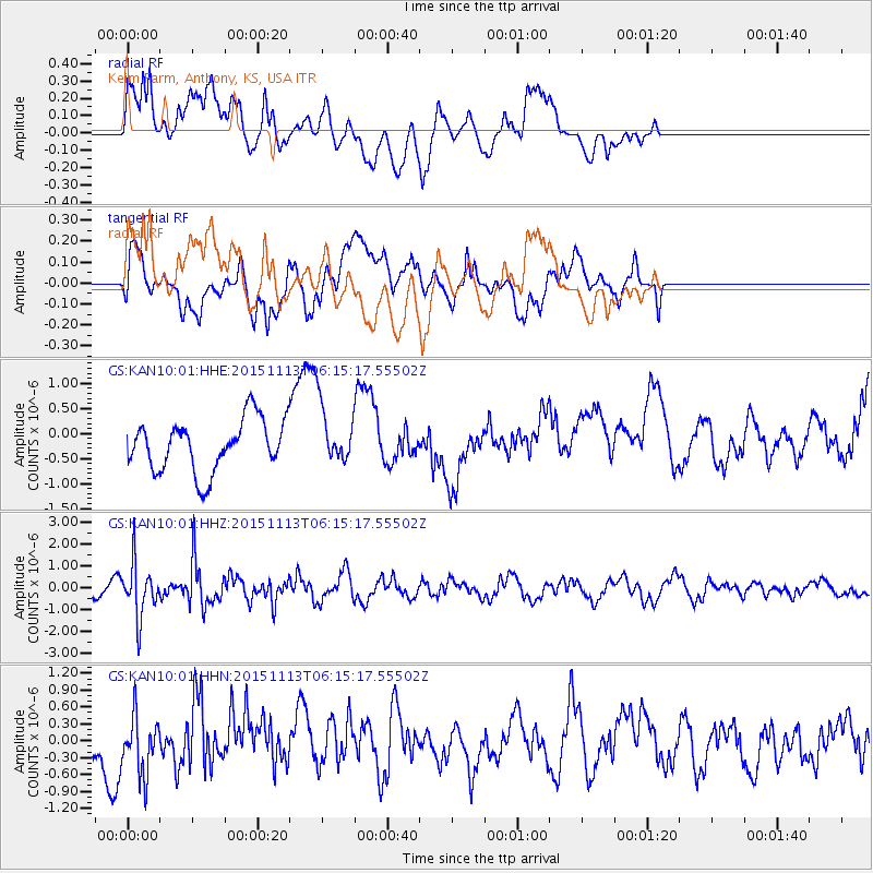
Signal To Noise
| Channel | StoN | STA | LTA |
| GS:KAN10:01:HHZ:20151113T06:15:17.55502Z | 2.6163971 | 1.2131699E-6 | 4.6367956E-7 |
| GS:KAN10:01:HHN:20151113T06:15:17.55502Z | 0.83792454 | 5.337373E-7 | 6.3697536E-7 |
| GS:KAN10:01:HHE:20151113T06:15:17.55502Z | 1.1637985 | 5.941937E-7 | 5.1056406E-7 |
| Arrivals |
| Ps | |
| PpPs | |
| PsPs/PpSs | |


