You are here: Home > Network List > TJ - Tajikistan National Seismic Network Stations List
> Station GARM Garm, Tajikistan > Earthquake Result Viewer
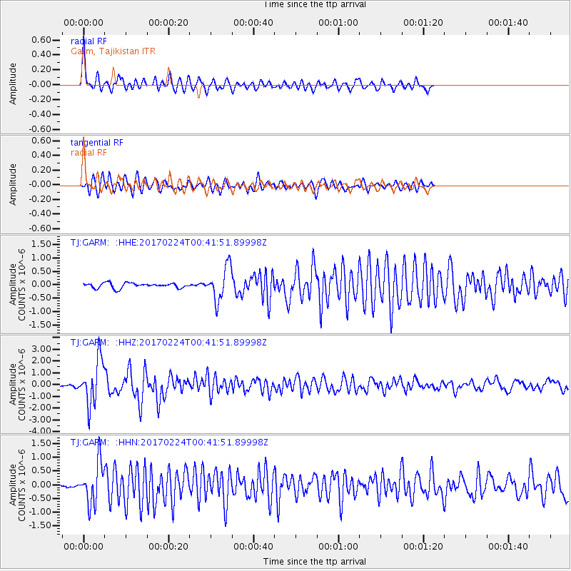
GARM Garm, Tajikistan - Earthquake Result Viewer
*The percent match for this event was below the threshold and hence no stack was calculated.
| Earthquake location: |
Lake Tanganyika Region |
| Earthquake latitude/longitude: |
-8.5/30.1 |
| Earthquake time(UTC): |
2017/02/24 (055) 00:32:17 GMT |
| Earthquake Depth: |
27 km |
| Earthquake Magnitude: |
5.9 Mww |
| Earthquake Catalog/Contributor: |
NEIC PDE/us |
|
| Network: |
TJ Tajikistan National Seismic Network |
| Station: |
GARM Garm, Tajikistan |
| Lat/Lon: |
39.00 N/70.32 E |
| Elevation: |
1305 m |
|
| Distance: |
60.2 deg |
| Az: |
35.442 deg |
| Baz: |
227.408 deg |
| Ray Param: |
$rayparam |
*The percent match for this event was below the threshold and hence was not used in the summary stack. |
|
| Radial Match: |
77.62524 % |
| Radial Bump: |
400 |
| Transverse Match: |
70.5907 % |
| Transverse Bump: |
400 |
| SOD ConfigId: |
11737051 |
| Insert Time: |
2019-04-26 19:52:06.102 +0000 |
| GWidth: |
2.5 |
| Max Bumps: |
400 |
| Tol: |
0.001 |
|
Signal To Noise
| Channel | StoN | STA | LTA |
| TJ:GARM: :HHZ:20170224T00:41:51.89998Z | 9.089201 | 1.9438835E-6 | 2.1386737E-7 |
| TJ:GARM: :HHN:20170224T00:41:51.89998Z | 5.3385243 | 7.626923E-7 | 1.4286576E-7 |
| TJ:GARM: :HHE:20170224T00:41:51.89998Z | 6.76775 | 6.3697536E-7 | 9.411922E-8 |
| Arrivals |
| Ps | |
| PpPs | |
| PsPs/PpSs | |


