You are here: Home > Network List > AV - Alaska Volcano Observatory Stations List
> Station AUCH Augustine Cone H, Augustine Volcano, Alaska > Earthquake Result Viewer
AUCH Augustine Cone H, Augustine Volcano, Alaska - Earthquake Result Viewer
| Earthquake location: |
South Of Fiji Islands |
| Earthquake latitude/longitude: |
-23.2/-178.8 |
| Earthquake time(UTC): |
2017/02/24 (055) 17:28:44 GMT |
| Earthquake Depth: |
415 km |
| Earthquake Magnitude: |
6.9 mww |
| Earthquake Catalog/Contributor: |
NEIC PDE/us |
|
| Network: |
AV Alaska Volcano Observatory |
| Station: |
AUCH Augustine Cone H, Augustine Volcano, Alaska |
| Lat/Lon: |
59.36 N/153.44 W |
| Elevation: |
916 m |
|
| Distance: |
84.9 deg |
| Az: |
12.736 deg |
| Baz: |
203.324 deg |
| Ray Param: |
0.04403195 |
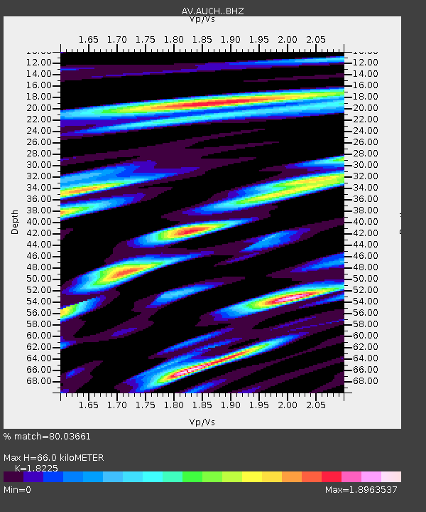
| Estimated Moho Depth: |
66.0 km |
| Estimated Crust Vp/Vs: |
1.82 |
| Assumed Crust Vp: |
5.989 km/s |
| Estimated Crust Vs: |
3.286 km/s |
| Estimated Crust Poisson's Ratio: |
0.28 |
|
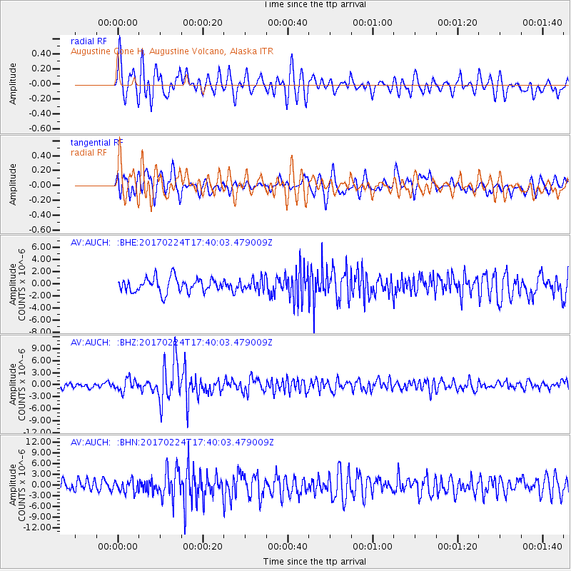
| Radial Match: |
80.03661 % |
| Radial Bump: |
400 |
| Transverse Match: |
65.11925 % |
| Transverse Bump: |
400 |
| SOD ConfigId: |
11737051 |
| Insert Time: |
2019-04-26 19:54:53.303 +0000 |
| GWidth: |
2.5 |
| Max Bumps: |
400 |
| Tol: |
0.001 |
|
Signal To Noise
| Channel | StoN | STA | LTA |
| AV:AUCH: :BHZ:20170224T17:40:03.479009Z | 2.4771152 | 1.5747005E-6 | 6.3569934E-7 |
| AV:AUCH: :BHN:20170224T17:40:03.479009Z | 1.2807624 | 1.6914605E-6 | 1.3206669E-6 |
| AV:AUCH: :BHE:20170224T17:40:03.479009Z | 0.87964803 | 1.0265115E-6 | 1.1669572E-6 |
| Arrivals |
| Ps | 9.2 SECOND |
| PpPs | 31 SECOND |
| PsPs/PpSs | 40 SECOND |


