You are here: Home > Network List > CI - Caltech Regional Seismic Network Stations List
> Station RPV Rancho Palos Verdes, California, USA > Earthquake Result Viewer
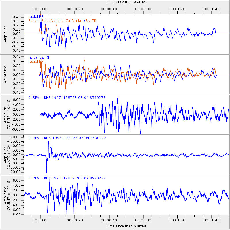
RPV Rancho Palos Verdes, California, USA - Earthquake Result Viewer
*The percent match for this event was below the threshold and hence no stack was calculated.
| Earthquake location: |
Peru-Bolivia Border Region |
| Earthquake latitude/longitude: |
-13.7/-68.8 |
| Earthquake time(UTC): |
1997/11/28 (332) 22:53:41 GMT |
| Earthquake Depth: |
586 km |
| Earthquake Magnitude: |
6.4 MB, 6.6 UNKNOWN, 6.6 MW |
| Earthquake Catalog/Contributor: |
WHDF/NEIC |
|
| Network: |
CI Caltech Regional Seismic Network |
| Station: |
RPV Rancho Palos Verdes, California, USA |
| Lat/Lon: |
33.74 N/118.40 W |
| Elevation: |
64 m |
|
| Distance: |
66.8 deg |
| Az: |
316.322 deg |
| Baz: |
126.352 deg |
| Ray Param: |
$rayparam |
*The percent match for this event was below the threshold and hence was not used in the summary stack. |
|
| Radial Match: |
84.06752 % |
| Radial Bump: |
400 |
| Transverse Match: |
80.88965 % |
| Transverse Bump: |
400 |
| SOD ConfigId: |
4480 |
| Insert Time: |
2010-03-05 22:10:32.705 +0000 |
| GWidth: |
2.5 |
| Max Bumps: |
400 |
| Tol: |
0.001 |
|
Signal To Noise
| Channel | StoN | STA | LTA |
| CI:RPV: :BHN:19971128T23:03:04.853027Z | 13.86544 | 6.554241E-6 | 4.7270342E-7 |
| CI:RPV: :BHE:19971128T23:03:04.853027Z | 2.567936 | 2.3059408E-6 | 8.979744E-7 |
| CI:RPV: :BHZ:19971128T23:03:04.853027Z | 2.4013603 | 1.8212064E-6 | 7.584062E-7 |
| Arrivals |
| Ps | |
| PpPs | |
| PsPs/PpSs | |


