You are here: Home > Network List > GT - Global Telemetered Seismograph Network (USAF/USGS) Stations List
> Station PLCA Paso Flores, Argentina > Earthquake Result Viewer
PLCA Paso Flores, Argentina - Earthquake Result Viewer

| Earthquake location: |
South Of Fiji Islands |
| Earthquake latitude/longitude: |
-23.2/-178.8 |
| Earthquake time(UTC): |
2017/02/24 (055) 17:28:44 GMT |
| Earthquake Depth: |
415 km |
| Earthquake Magnitude: |
6.9 mww |
| Earthquake Catalog/Contributor: |
NEIC PDE/us |
|
| Network: |
GT Global Telemetered Seismograph Network (USAF/USGS) |
| Station: |
PLCA Paso Flores, Argentina |
| Lat/Lon: |
40.73 S/70.55 W |
| Elevation: |
1050 m |
|
| Distance: |
87.9 deg |
| Az: |
133.778 deg |
| Baz: |
240.916 deg |
| Ray Param: |
0.041874558 |
| Estimated Moho Depth: |
30.0 km |
| Estimated Crust Vp/Vs: |
1.94 |
| Assumed Crust Vp: |
6.597 km/s |
| Estimated Crust Vs: |
3.401 km/s |
| Estimated Crust Poisson's Ratio: |
0.32 |
|
| Radial Match: |
81.43551 % |
| Radial Bump: |
329 |
| Transverse Match: |
45.972847 % |
| Transverse Bump: |
400 |
| SOD ConfigId: |
11737051 |
| Insert Time: |
2019-04-26 19:57:11.435 +0000 |
| GWidth: |
2.5 |
| Max Bumps: |
400 |
| Tol: |
0.001 |
|
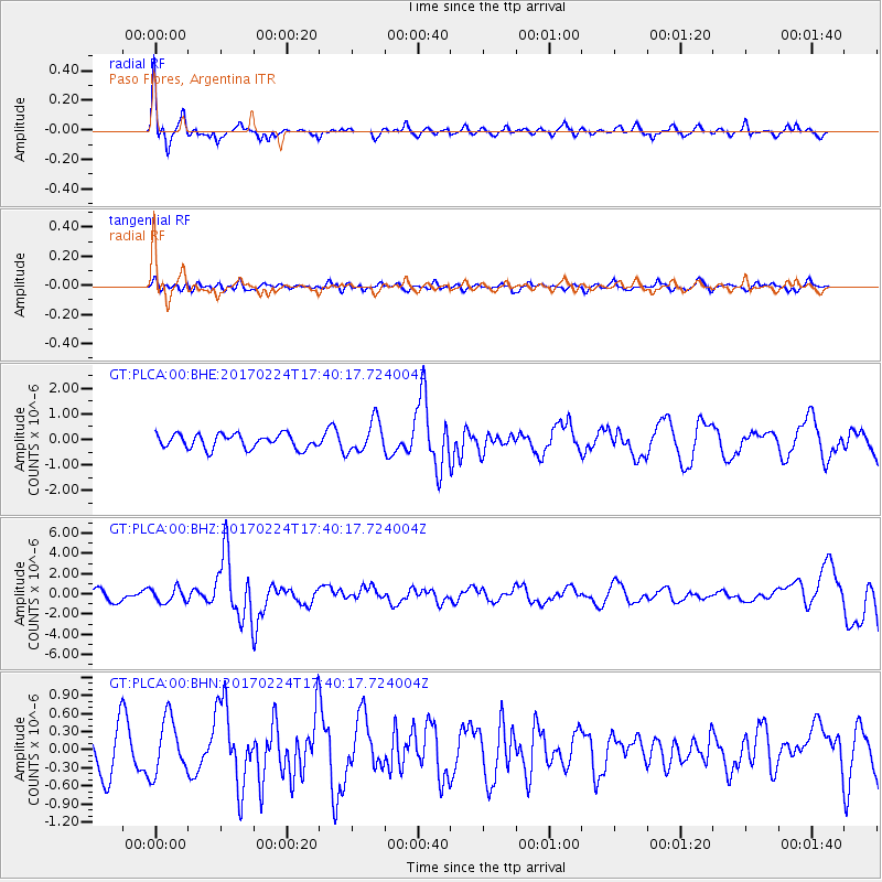
Signal To Noise
| Channel | StoN | STA | LTA |
| GT:PLCA:00:BHZ:20170224T17:40:17.724004Z | 1.5728654 | 7.021849E-7 | 4.4643676E-7 |
| GT:PLCA:00:BHN:20170224T17:40:17.724004Z | 1.3087558 | 4.5890116E-7 | 3.5063925E-7 |
| GT:PLCA:00:BHE:20170224T17:40:17.724004Z | 2.1965773 | 6.1162024E-7 | 2.784424E-7 |
| Arrivals |
| Ps | 4.4 SECOND |
| PpPs | 13 SECOND |
| PsPs/PpSs | 17 SECOND |


