You are here: Home > Network List > CI - Caltech Regional Seismic Network Stations List
> Station RCT Rector, Visalia, CA, USA > Earthquake Result Viewer
RCT Rector, Visalia, CA, USA - Earthquake Result Viewer
| Earthquake location: |
Near Coast Of Nicaragua |
| Earthquake latitude/longitude: |
11.4/-86.7 |
| Earthquake time(UTC): |
2004/10/09 (283) 21:26:53 GMT |
| Earthquake Depth: |
35 km |
| Earthquake Magnitude: |
6.0 MB, 7.0 MS, 6.9 MW, 6.8 MW |
| Earthquake Catalog/Contributor: |
WHDF/NEIC |
|
| Network: |
CI Caltech Regional Seismic Network |
| Station: |
RCT Rector, Visalia, CA, USA |
| Lat/Lon: |
36.31 N/119.24 W |
| Elevation: |
107 m |
|
| Distance: |
38.4 deg |
| Az: |
315.593 deg |
| Baz: |
121.86 deg |
| Ray Param: |
0.07549574 |
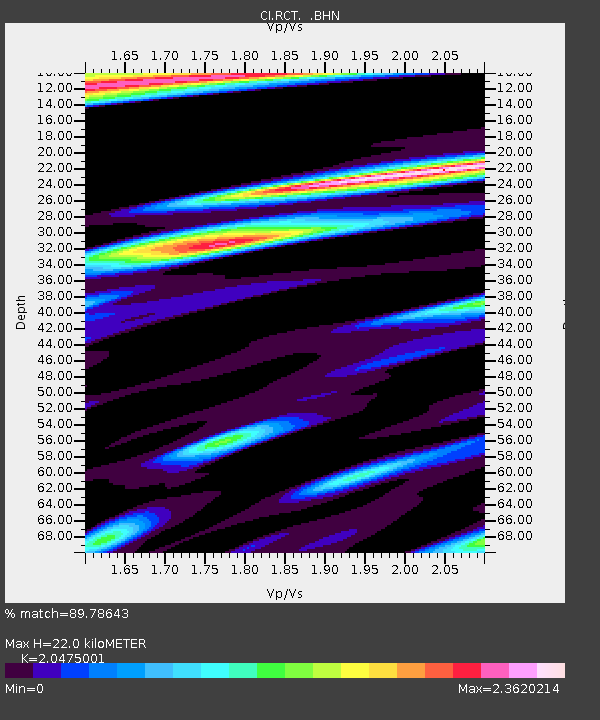
| Estimated Moho Depth: |
22.0 km |
| Estimated Crust Vp/Vs: |
2.05 |
| Assumed Crust Vp: |
6.291 km/s |
| Estimated Crust Vs: |
3.073 km/s |
| Estimated Crust Poisson's Ratio: |
0.34 |
|
| Radial Match: |
89.78643 % |
| Radial Bump: |
400 |
| Transverse Match: |
79.67954 % |
| Transverse Bump: |
400 |
| SOD ConfigId: |
2459 |
| Insert Time: |
2010-03-05 22:10:49.916 +0000 |
| GWidth: |
2.5 |
| Max Bumps: |
400 |
| Tol: |
0.001 |
|
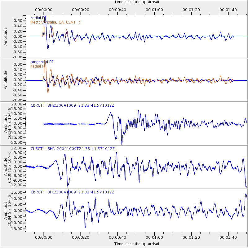
Signal To Noise
| Channel | StoN | STA | LTA |
| CI:RCT: :BHN:20041009T21:33:41.571012Z | 1.6619701 | 8.4193016E-7 | 5.065856E-7 |
| CI:RCT: :BHE:20041009T21:33:41.571012Z | 1.2110949 | 7.9693257E-7 | 6.580265E-7 |
| CI:RCT: :BHZ:20041009T21:33:41.571012Z | 7.3790965 | 1.6452276E-6 | 2.2295787E-7 |
| Arrivals |
| Ps | 3.9 SECOND |
| PpPs | 10 SECOND |
| PsPs/PpSs | 14 SECOND |


