You are here: Home > Network List > CI - Caltech Regional Seismic Network Stations List
> Station RCT Rector, Visalia, CA, USA > Earthquake Result Viewer
RCT Rector, Visalia, CA, USA - Earthquake Result Viewer
| Earthquake location: |
Solomon Islands |
| Earthquake latitude/longitude: |
-11.0/162.2 |
| Earthquake time(UTC): |
2004/10/08 (282) 08:27:53 GMT |
| Earthquake Depth: |
36 km |
| Earthquake Magnitude: |
6.1 MB, 6.9 MS, 6.8 MW, 6.8 MW |
| Earthquake Catalog/Contributor: |
WHDF/NEIC |
|
| Network: |
CI Caltech Regional Seismic Network |
| Station: |
RCT Rector, Visalia, CA, USA |
| Lat/Lon: |
36.31 N/119.24 W |
| Elevation: |
107 m |
|
| Distance: |
87.4 deg |
| Az: |
52.433 deg |
| Baz: |
254.502 deg |
| Ray Param: |
0.04331451 |
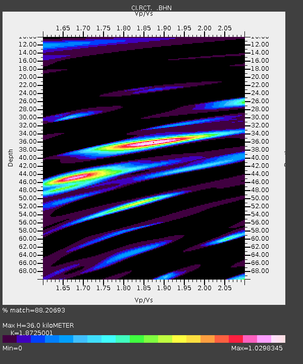
| Estimated Moho Depth: |
36.0 km |
| Estimated Crust Vp/Vs: |
1.87 |
| Assumed Crust Vp: |
6.291 km/s |
| Estimated Crust Vs: |
3.36 km/s |
| Estimated Crust Poisson's Ratio: |
0.30 |
|
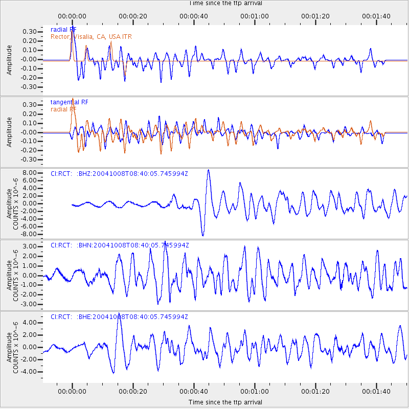
| Radial Match: |
88.20693 % |
| Radial Bump: |
400 |
| Transverse Match: |
79.01367 % |
| Transverse Bump: |
400 |
| SOD ConfigId: |
2459 |
| Insert Time: |
2010-03-05 22:10:53.178 +0000 |
| GWidth: |
2.5 |
| Max Bumps: |
400 |
| Tol: |
0.001 |
|
Signal To Noise
| Channel | StoN | STA | LTA |
| CI:RCT: :BHN:20041008T08:40:05.745994Z | 1.0152042 | 5.2204257E-7 | 5.142242E-7 |
| CI:RCT: :BHE:20041008T08:40:05.745994Z | 0.78735805 | 4.0759141E-7 | 5.176697E-7 |
| CI:RCT: :BHZ:20041008T08:40:05.745994Z | 2.4078522 | 1.1481956E-6 | 4.7685467E-7 |
| Arrivals |
| Ps | 5.1 SECOND |
| PpPs | 16 SECOND |
| PsPs/PpSs | 21 SECOND |


