You are here: Home > Network List > CI - Caltech Regional Seismic Network Stations List
> Station RCT Rector, Visalia, CA, USA > Earthquake Result Viewer
RCT Rector, Visalia, CA, USA - Earthquake Result Viewer
| Earthquake location: |
Near S. Coast Of Western Honshu |
| Earthquake latitude/longitude: |
33.1/136.6 |
| Earthquake time(UTC): |
2004/09/05 (249) 10:07:07 GMT |
| Earthquake Depth: |
14 km |
| Earthquake Magnitude: |
6.7 MB, 7.0 MS, 7.2 MW, 7.0 MW |
| Earthquake Catalog/Contributor: |
WHDF/NEIC |
|
| Network: |
CI Caltech Regional Seismic Network |
| Station: |
RCT Rector, Visalia, CA, USA |
| Lat/Lon: |
36.31 N/119.24 W |
| Elevation: |
107 m |
|
| Distance: |
81.1 deg |
| Az: |
52.449 deg |
| Baz: |
304.499 deg |
| Ray Param: |
0.047807492 |
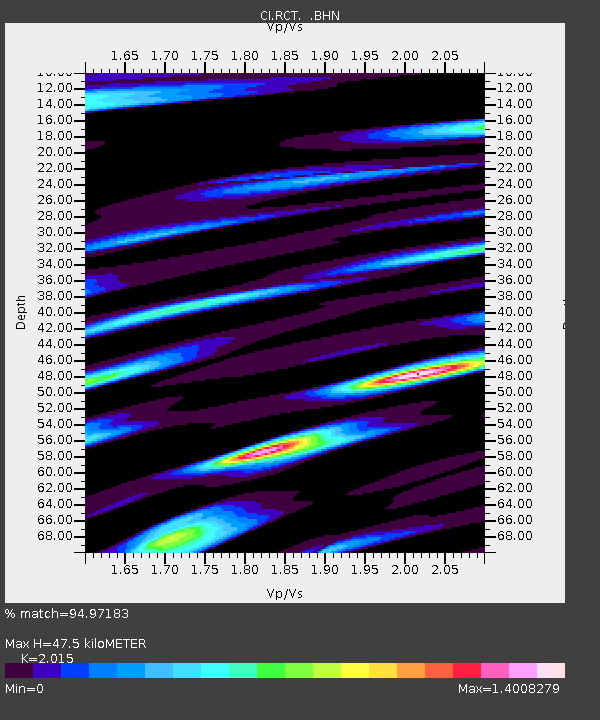
| Estimated Moho Depth: |
47.5 km |
| Estimated Crust Vp/Vs: |
2.02 |
| Assumed Crust Vp: |
6.291 km/s |
| Estimated Crust Vs: |
3.122 km/s |
| Estimated Crust Poisson's Ratio: |
0.34 |
|
| Radial Match: |
94.97183 % |
| Radial Bump: |
400 |
| Transverse Match: |
89.94866 % |
| Transverse Bump: |
400 |
| SOD ConfigId: |
2459 |
| Insert Time: |
2010-03-05 22:10:57.664 +0000 |
| GWidth: |
2.5 |
| Max Bumps: |
400 |
| Tol: |
0.001 |
|
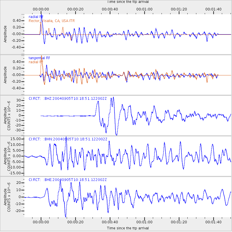
Signal To Noise
| Channel | StoN | STA | LTA |
| CI:RCT: :BHN:20040905T10:18:51.122002Z | 6.6707253 | 3.5146534E-6 | 5.268773E-7 |
| CI:RCT: :BHE:20040905T10:18:51.122002Z | 12.353983 | 5.978498E-6 | 4.839328E-7 |
| CI:RCT: :BHZ:20040905T10:18:51.122002Z | 83.11963 | 1.4290323E-5 | 1.7192475E-7 |
| Arrivals |
| Ps | 7.8 SECOND |
| PpPs | 22 SECOND |
| PsPs/PpSs | 30 SECOND |


