You are here: Home > Network List > CI - Caltech Regional Seismic Network Stations List
> Station RCT Rector, Visalia, CA, USA > Earthquake Result Viewer
RCT Rector, Visalia, CA, USA - Earthquake Result Viewer
| Earthquake location: |
South Of Aleutian Islands |
| Earthquake latitude/longitude: |
51.8/-166.3 |
| Earthquake time(UTC): |
2004/08/07 (220) 09:30:16 GMT |
| Earthquake Depth: |
8.0 km |
| Earthquake Magnitude: |
6.3 MB, 5.4 MS, 6.0 MW, 6.0 MW |
| Earthquake Catalog/Contributor: |
WHDF/NEIC |
|
| Network: |
CI Caltech Regional Seismic Network |
| Station: |
RCT Rector, Visalia, CA, USA |
| Lat/Lon: |
36.31 N/119.24 W |
| Elevation: |
107 m |
|
| Distance: |
36.5 deg |
| Az: |
96.226 deg |
| Baz: |
310.092 deg |
| Ray Param: |
0.07664733 |
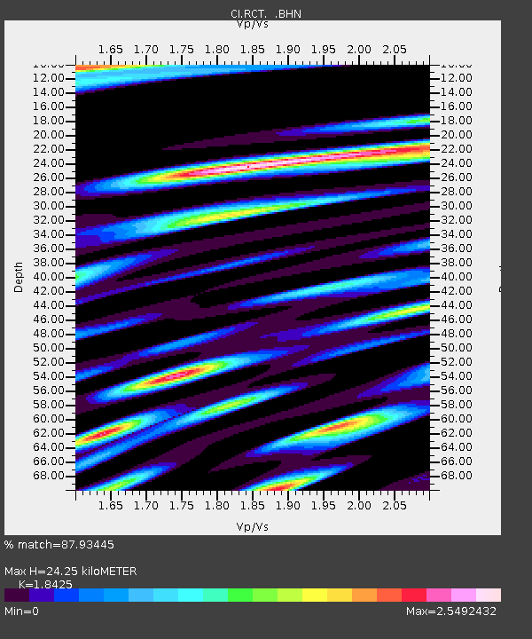
| Estimated Moho Depth: |
24.25 km |
| Estimated Crust Vp/Vs: |
1.84 |
| Assumed Crust Vp: |
6.291 km/s |
| Estimated Crust Vs: |
3.415 km/s |
| Estimated Crust Poisson's Ratio: |
0.29 |
|
| Radial Match: |
87.93445 % |
| Radial Bump: |
400 |
| Transverse Match: |
80.61733 % |
| Transverse Bump: |
400 |
| SOD ConfigId: |
2459 |
| Insert Time: |
2010-03-05 22:10:59.697 +0000 |
| GWidth: |
2.5 |
| Max Bumps: |
400 |
| Tol: |
0.001 |
|
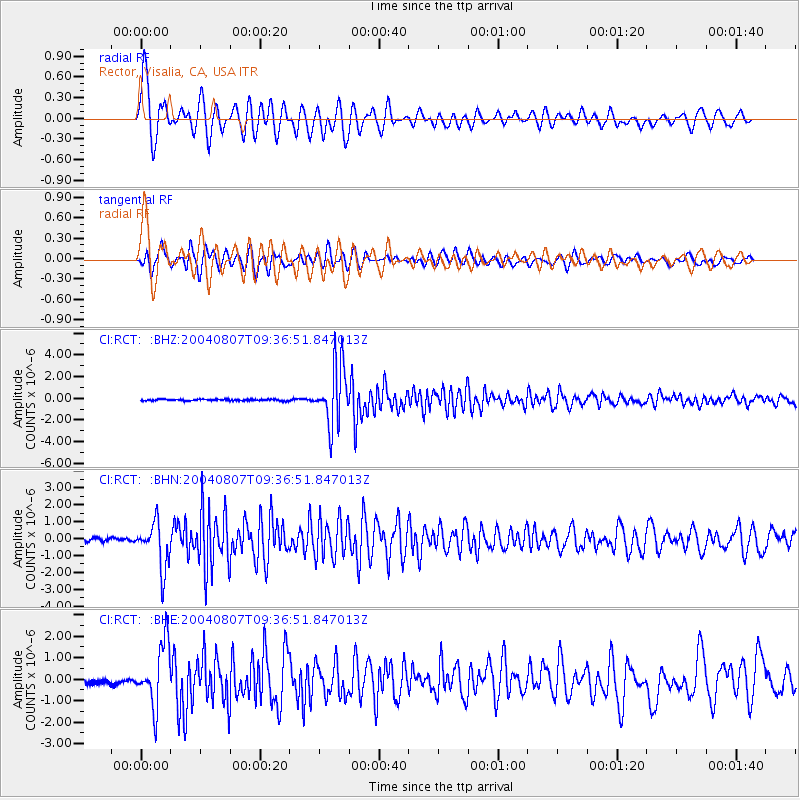
Signal To Noise
| Channel | StoN | STA | LTA |
| CI:RCT: :BHN:20040807T09:36:51.847013Z | 12.873546 | 1.3775324E-6 | 1.070049E-7 |
| CI:RCT: :BHE:20040807T09:36:51.847013Z | 8.697971 | 1.4292679E-6 | 1.6432197E-7 |
| CI:RCT: :BHZ:20040807T09:36:51.847013Z | 39.596287 | 2.728596E-6 | 6.89104E-8 |
| Arrivals |
| Ps | 3.5 SECOND |
| PpPs | 10 SECOND |
| PsPs/PpSs | 14 SECOND |


