You are here: Home > Network List > TA - USArray Transportable Network (new EarthScope stations) Stations List
> Station P17K Kvichak River, AK, USA > Earthquake Result Viewer
P17K Kvichak River, AK, USA - Earthquake Result Viewer
| Earthquake location: |
South Of Fiji Islands |
| Earthquake latitude/longitude: |
-23.2/-178.8 |
| Earthquake time(UTC): |
2017/02/24 (055) 17:28:44 GMT |
| Earthquake Depth: |
415 km |
| Earthquake Magnitude: |
6.9 mww |
| Earthquake Catalog/Contributor: |
NEIC PDE/us |
|
| Network: |
TA USArray Transportable Network (new EarthScope stations) |
| Station: |
P17K Kvichak River, AK, USA |
| Lat/Lon: |
59.20 N/156.44 W |
| Elevation: |
91 m |
|
| Distance: |
84.2 deg |
| Az: |
11.367 deg |
| Baz: |
200.624 deg |
| Ray Param: |
0.04453613 |
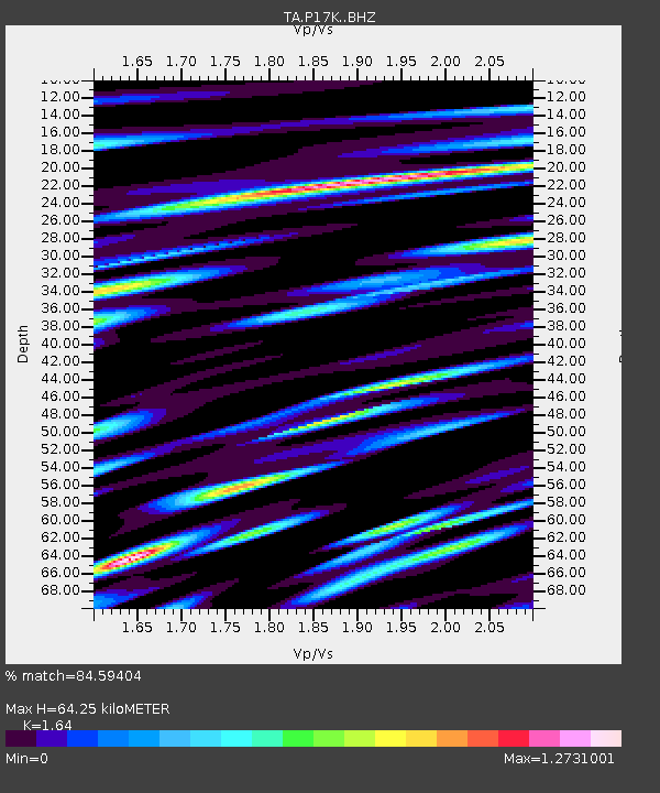
| Estimated Moho Depth: |
64.25 km |
| Estimated Crust Vp/Vs: |
1.64 |
| Assumed Crust Vp: |
6.276 km/s |
| Estimated Crust Vs: |
3.827 km/s |
| Estimated Crust Poisson's Ratio: |
0.20 |
|
| Radial Match: |
84.59404 % |
| Radial Bump: |
400 |
| Transverse Match: |
78.3205 % |
| Transverse Bump: |
400 |
| SOD ConfigId: |
11737051 |
| Insert Time: |
2019-04-26 19:59:35.940 +0000 |
| GWidth: |
2.5 |
| Max Bumps: |
400 |
| Tol: |
0.001 |
|
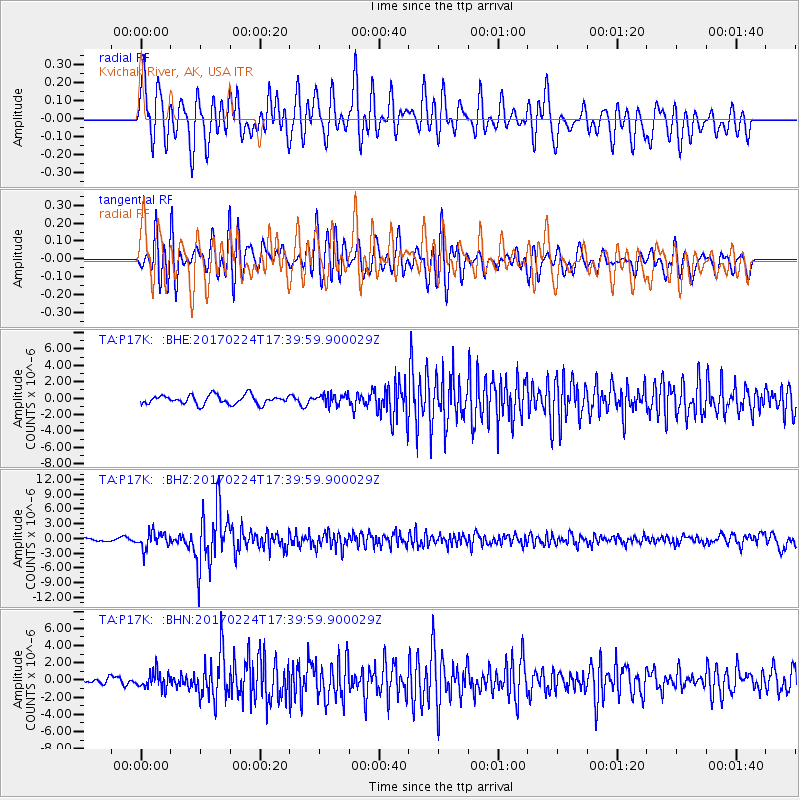
Signal To Noise
| Channel | StoN | STA | LTA |
| TA:P17K: :BHZ:20170224T17:39:59.900029Z | 7.2642303 | 1.6744091E-6 | 2.3050056E-7 |
| TA:P17K: :BHN:20170224T17:39:59.900029Z | 2.4961388 | 9.608827E-7 | 3.8494764E-7 |
| TA:P17K: :BHE:20170224T17:39:59.900029Z | 1.1620392 | 6.3726236E-7 | 5.4840007E-7 |
| Arrivals |
| Ps | 6.7 SECOND |
| PpPs | 26 SECOND |
| PsPs/PpSs | 33 SECOND |


