You are here: Home > Network List > CI - Caltech Regional Seismic Network Stations List
> Station RCT Rector, Visalia, CA, USA > Earthquake Result Viewer
RCT Rector, Visalia, CA, USA - Earthquake Result Viewer
| Earthquake location: |
Mariana Islands |
| Earthquake latitude/longitude: |
20.1/145.8 |
| Earthquake time(UTC): |
2005/08/13 (225) 07:36:52 GMT |
| Earthquake Depth: |
49 km |
| Earthquake Magnitude: |
5.8 MB, 5.6 MS, 6.0 MW, 6.0 MW |
| Earthquake Catalog/Contributor: |
WHDF/NEIC |
|
| Network: |
CI Caltech Regional Seismic Network |
| Station: |
RCT Rector, Visalia, CA, USA |
| Lat/Lon: |
36.31 N/119.24 W |
| Elevation: |
107 m |
|
| Distance: |
82.2 deg |
| Az: |
54.322 deg |
| Baz: |
289.105 deg |
| Ray Param: |
0.046986885 |
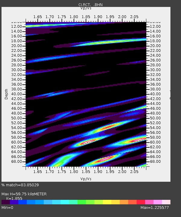
| Estimated Moho Depth: |
59.75 km |
| Estimated Crust Vp/Vs: |
1.86 |
| Assumed Crust Vp: |
6.291 km/s |
| Estimated Crust Vs: |
3.392 km/s |
| Estimated Crust Poisson's Ratio: |
0.30 |
|
| Radial Match: |
83.85029 % |
| Radial Bump: |
400 |
| Transverse Match: |
68.1667 % |
| Transverse Bump: |
400 |
| SOD ConfigId: |
2422 |
| Insert Time: |
2010-03-05 22:11:16.505 +0000 |
| GWidth: |
2.5 |
| Max Bumps: |
400 |
| Tol: |
0.001 |
|
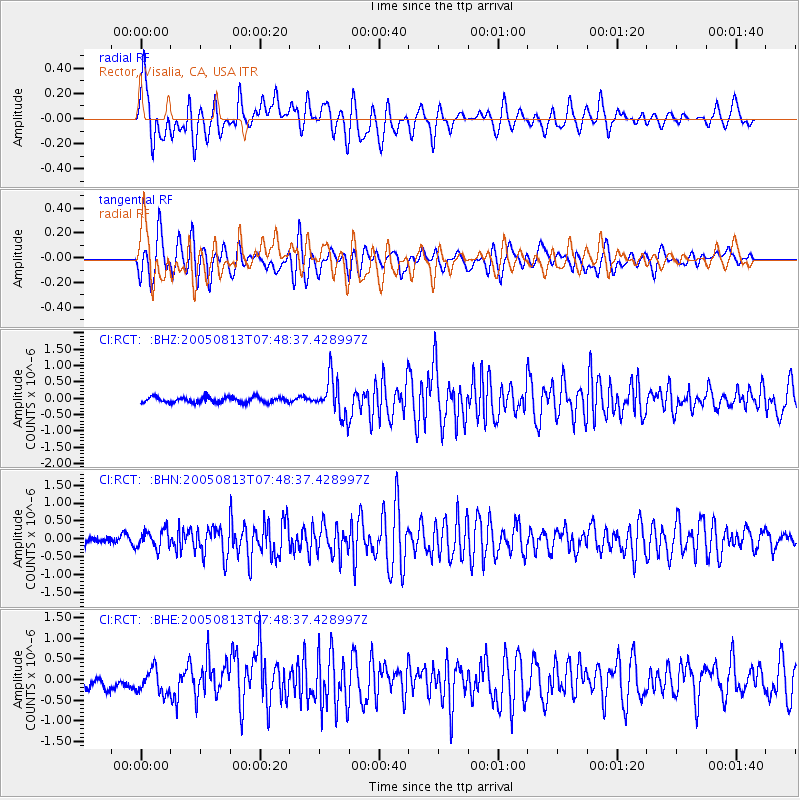
Signal To Noise
| Channel | StoN | STA | LTA |
| CI:RCT: :BHN:20050813T07:48:37.428997Z | 2.1383607 | 2.5879828E-7 | 1.2102649E-7 |
| CI:RCT: :BHE:20050813T07:48:37.428997Z | 1.9384643 | 2.931825E-7 | 1.5124472E-7 |
| CI:RCT: :BHZ:20050813T07:48:37.428997Z | 7.038252 | 5.8130735E-7 | 8.259257E-8 |
| Arrivals |
| Ps | 8.3 SECOND |
| PpPs | 26 SECOND |
| PsPs/PpSs | 35 SECOND |


