You are here: Home > Network List > CI - Caltech Regional Seismic Network Stations List
> Station RCT Rector, Visalia, CA, USA > Earthquake Result Viewer
RCT Rector, Visalia, CA, USA - Earthquake Result Viewer
| Earthquake location: |
Near S. Coast Of Honshu, Japan |
| Earthquake latitude/longitude: |
35.5/140.0 |
| Earthquake time(UTC): |
2005/07/23 (204) 07:34:56 GMT |
| Earthquake Depth: |
61 km |
| Earthquake Magnitude: |
6.1 MB, 6.0 MW, 6.0 MW |
| Earthquake Catalog/Contributor: |
WHDF/NEIC |
|
| Network: |
CI Caltech Regional Seismic Network |
| Station: |
RCT Rector, Visalia, CA, USA |
| Lat/Lon: |
36.31 N/119.24 W |
| Elevation: |
107 m |
|
| Distance: |
77.4 deg |
| Az: |
54.39 deg |
| Baz: |
304.789 deg |
| Ray Param: |
0.05020349 |
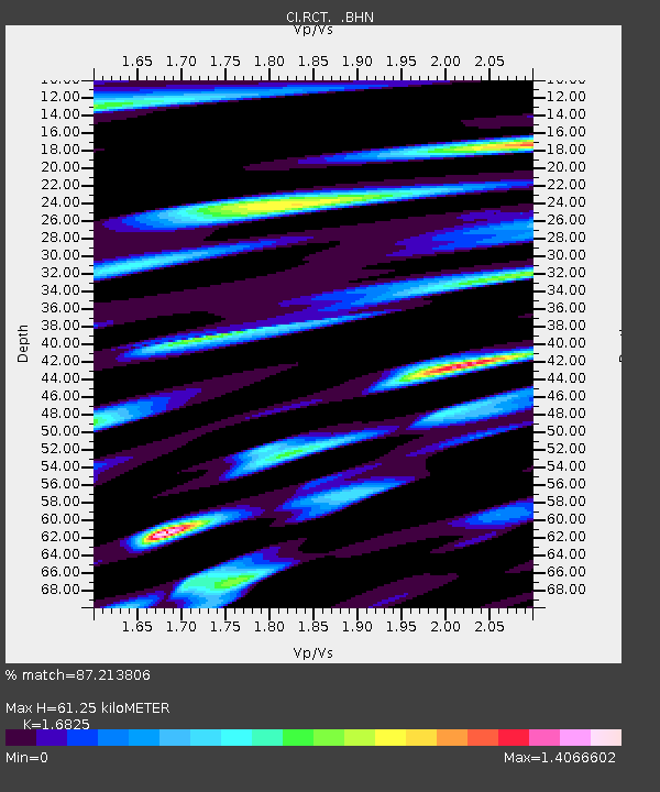
| Estimated Moho Depth: |
61.25 km |
| Estimated Crust Vp/Vs: |
1.68 |
| Assumed Crust Vp: |
6.291 km/s |
| Estimated Crust Vs: |
3.739 km/s |
| Estimated Crust Poisson's Ratio: |
0.23 |
|
| Radial Match: |
87.213806 % |
| Radial Bump: |
400 |
| Transverse Match: |
81.19115 % |
| Transverse Bump: |
400 |
| SOD ConfigId: |
2475 |
| Insert Time: |
2010-03-05 22:11:22.825 +0000 |
| GWidth: |
2.5 |
| Max Bumps: |
400 |
| Tol: |
0.001 |
|
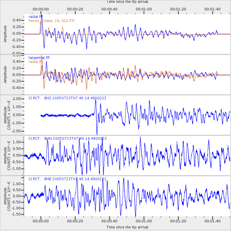
Signal To Noise
| Channel | StoN | STA | LTA |
| CI:RCT: :BHN:20050723T07:46:14.480022Z | 3.9029362 | 4.6510385E-7 | 1.1916768E-7 |
| CI:RCT: :BHE:20050723T07:46:14.480022Z | 2.0657125 | 3.4788408E-7 | 1.6840877E-7 |
| CI:RCT: :BHZ:20050723T07:46:14.480022Z | 13.383434 | 9.750054E-7 | 7.2851655E-8 |
| Arrivals |
| Ps | 6.9 SECOND |
| PpPs | 25 SECOND |
| PsPs/PpSs | 32 SECOND |


