You are here: Home > Network List > CI - Caltech Regional Seismic Network Stations List
> Station RCT Rector, Visalia, CA, USA > Earthquake Result Viewer
RCT Rector, Visalia, CA, USA - Earthquake Result Viewer
| Earthquake location: |
New Ireland Region, P.N.G. |
| Earthquake latitude/longitude: |
-4.5/153.5 |
| Earthquake time(UTC): |
2005/09/09 (252) 07:26:43 GMT |
| Earthquake Depth: |
90 km |
| Earthquake Magnitude: |
6.3 MB, 7.7 MW, 7.5 MW |
| Earthquake Catalog/Contributor: |
WHDF/NEIC |
|
| Network: |
CI Caltech Regional Seismic Network |
| Station: |
RCT Rector, Visalia, CA, USA |
| Lat/Lon: |
36.31 N/119.24 W |
| Elevation: |
107 m |
|
| Distance: |
90.5 deg |
| Az: |
53.793 deg |
| Baz: |
264.758 deg |
| Ray Param: |
0.04165413 |
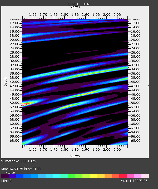
| Estimated Moho Depth: |
50.75 km |
| Estimated Crust Vp/Vs: |
1.60 |
| Assumed Crust Vp: |
6.291 km/s |
| Estimated Crust Vs: |
3.932 km/s |
| Estimated Crust Poisson's Ratio: |
0.18 |
|
| Radial Match: |
91.061325 % |
| Radial Bump: |
400 |
| Transverse Match: |
89.762665 % |
| Transverse Bump: |
400 |
| SOD ConfigId: |
2475 |
| Insert Time: |
2010-03-05 22:11:26.692 +0000 |
| GWidth: |
2.5 |
| Max Bumps: |
400 |
| Tol: |
0.001 |
|
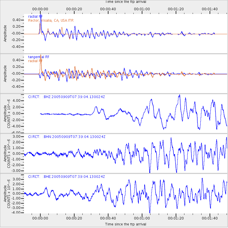
Signal To Noise
| Channel | StoN | STA | LTA |
| CI:RCT: :BHN:20050909T07:39:04.130024Z | 0.9335885 | 1.216811E-7 | 1.3033697E-7 |
| CI:RCT: :BHE:20050909T07:39:04.130024Z | 4.0398126 | 6.1434696E-7 | 1.5207314E-7 |
| CI:RCT: :BHZ:20050909T07:39:04.130024Z | 11.939698 | 1.1967777E-6 | 1.0023517E-7 |
| Arrivals |
| Ps | 4.9 SECOND |
| PpPs | 21 SECOND |
| PsPs/PpSs | 25 SECOND |


