You are here: Home > Network List > UW - Pacific Northwest Regional Seismic Network Stations List
> Station YACT Amboy, WA, USA > Earthquake Result Viewer
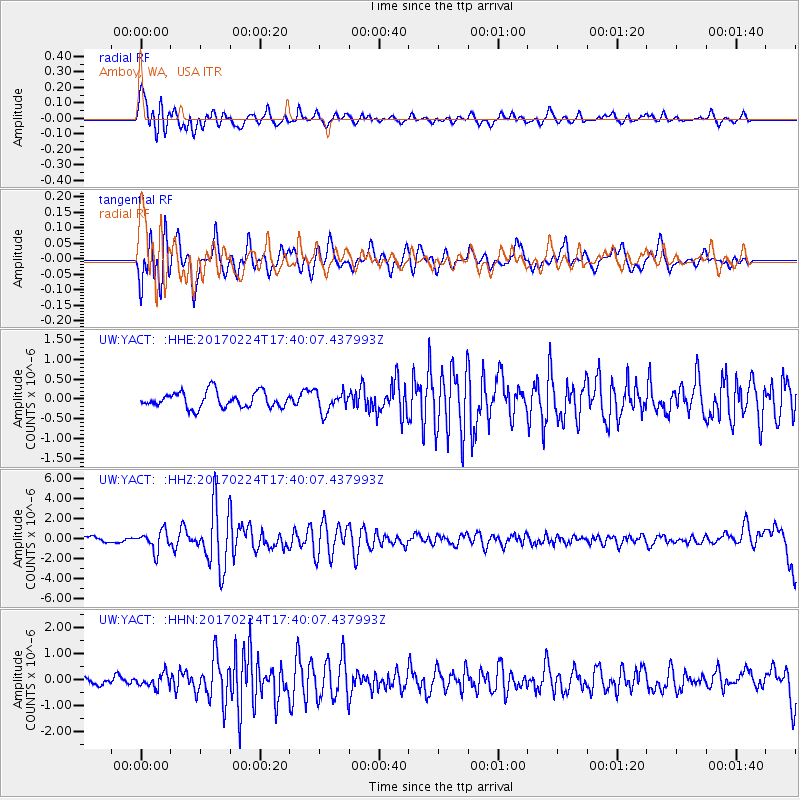
YACT Amboy, WA, USA - Earthquake Result Viewer
*The percent match for this event was below the threshold and hence no stack was calculated.
| Earthquake location: |
South Of Fiji Islands |
| Earthquake latitude/longitude: |
-23.2/-178.8 |
| Earthquake time(UTC): |
2017/02/24 (055) 17:28:44 GMT |
| Earthquake Depth: |
415 km |
| Earthquake Magnitude: |
6.9 mww |
| Earthquake Catalog/Contributor: |
NEIC PDE/us |
|
| Network: |
UW Pacific Northwest Regional Seismic Network |
| Station: |
YACT Amboy, WA, USA |
| Lat/Lon: |
45.93 N/122.42 W |
| Elevation: |
211 m |
|
| Distance: |
85.8 deg |
| Az: |
35.663 deg |
| Baz: |
230.206 deg |
| Ray Param: |
$rayparam |
*The percent match for this event was below the threshold and hence was not used in the summary stack. |
|
| Radial Match: |
78.100914 % |
| Radial Bump: |
400 |
| Transverse Match: |
70.26667 % |
| Transverse Bump: |
400 |
| SOD ConfigId: |
11737051 |
| Insert Time: |
2019-04-26 20:00:49.136 +0000 |
| GWidth: |
2.5 |
| Max Bumps: |
400 |
| Tol: |
0.001 |
|
Signal To Noise
| Channel | StoN | STA | LTA |
| UW:YACT: :HHZ:20170224T17:40:07.437993Z | 4.2336836 | 9.838775E-7 | 2.3239276E-7 |
| UW:YACT: :HHN:20170224T17:40:07.437993Z | 1.3573791 | 2.559087E-7 | 1.8853149E-7 |
| UW:YACT: :HHE:20170224T17:40:07.437993Z | 1.2833722 | 2.5754184E-7 | 2.0067588E-7 |
| Arrivals |
| Ps | |
| PpPs | |
| PsPs/PpSs | |


