You are here: Home > Network List > CI - Caltech Regional Seismic Network Stations List
> Station RCT Rector, Visalia, CA, USA > Earthquake Result Viewer
RCT Rector, Visalia, CA, USA - Earthquake Result Viewer
| Earthquake location: |
Andreanof Islands, Aleutian Is. |
| Earthquake latitude/longitude: |
51.4/-179.0 |
| Earthquake time(UTC): |
2007/12/21 (355) 07:24:34 GMT |
| Earthquake Depth: |
30 km |
| Earthquake Magnitude: |
6.1 MB, 6.2 MW, 6.3 ML |
| Earthquake Catalog/Contributor: |
WHDF/NEIC |
|
| Network: |
CI Caltech Regional Seismic Network |
| Station: |
RCT Rector, Visalia, CA, USA |
| Lat/Lon: |
36.31 N/119.24 W |
| Elevation: |
107 m |
|
| Distance: |
44.4 deg |
| Az: |
85.701 deg |
| Baz: |
309.283 deg |
| Ray Param: |
0.071887136 |
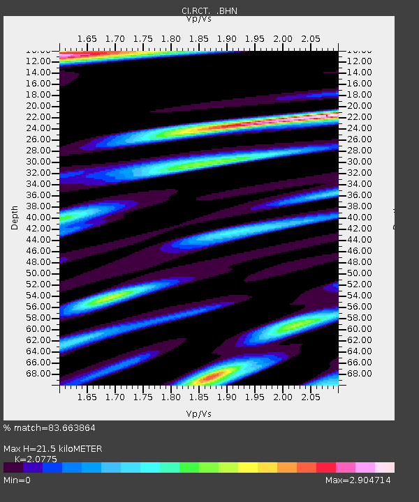
| Estimated Moho Depth: |
21.5 km |
| Estimated Crust Vp/Vs: |
2.08 |
| Assumed Crust Vp: |
6.291 km/s |
| Estimated Crust Vs: |
3.028 km/s |
| Estimated Crust Poisson's Ratio: |
0.35 |
|
| Radial Match: |
83.663864 % |
| Radial Bump: |
400 |
| Transverse Match: |
63.88694 % |
| Transverse Bump: |
400 |
| SOD ConfigId: |
2564 |
| Insert Time: |
2010-03-05 22:11:31.390 +0000 |
| GWidth: |
2.5 |
| Max Bumps: |
400 |
| Tol: |
0.001 |
|
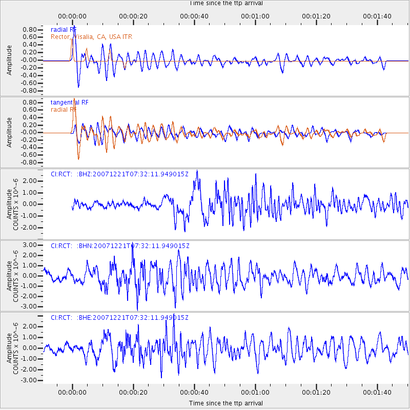
Signal To Noise
| Channel | StoN | STA | LTA |
| CI:RCT: :BHN:20071221T07:32:11.949015Z | 1.6486222 | 5.2672095E-7 | 3.1949162E-7 |
| CI:RCT: :BHE:20071221T07:32:11.949015Z | 1.2052547 | 4.656847E-7 | 3.8637867E-7 |
| CI:RCT: :BHZ:20071221T07:32:11.949015Z | 3.667588 | 8.1076183E-7 | 2.2106131E-7 |
| Arrivals |
| Ps | 3.9 SECOND |
| PpPs | 10.0 SECOND |
| PsPs/PpSs | 14 SECOND |


