You are here: Home > Network List > CI - Caltech Regional Seismic Network Stations List
> Station RCT Rector, Visalia, CA, USA > Earthquake Result Viewer
RCT Rector, Visalia, CA, USA - Earthquake Result Viewer
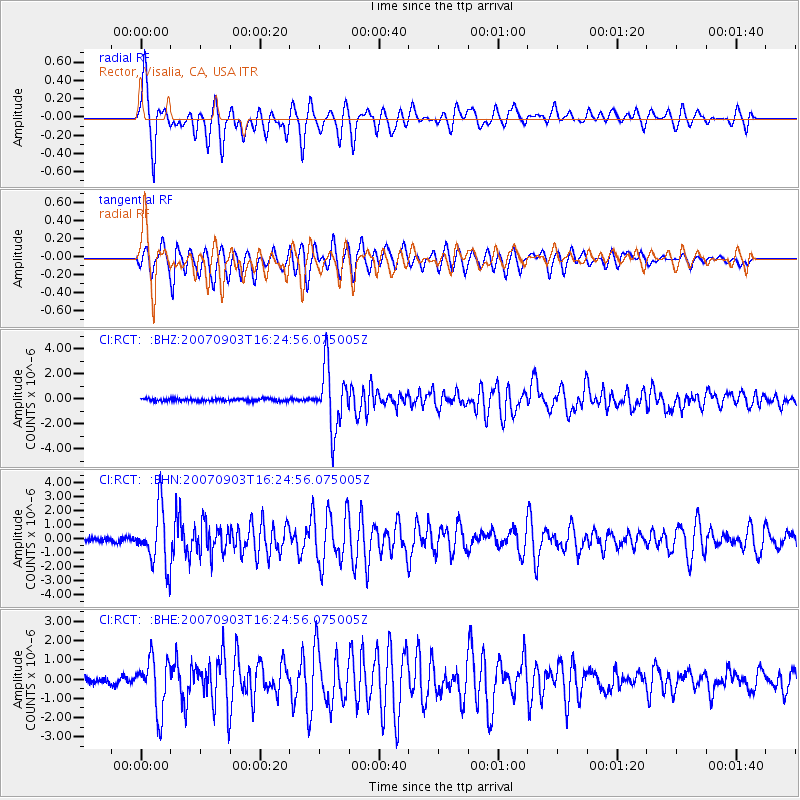
| Earthquake location: |
Kuril Islands |
| Earthquake latitude/longitude: |
45.8/150.1 |
| Earthquake time(UTC): |
2007/09/03 (246) 16:14:53 GMT |
| Earthquake Depth: |
94 km |
| Earthquake Magnitude: |
6.3 MB, 6.2 MW, 6.2 ME |
| Earthquake Catalog/Contributor: |
WHDF/NEIC |
|
| Network: |
CI Caltech Regional Seismic Network |
| Station: |
RCT Rector, Visalia, CA, USA |
| Lat/Lon: |
36.31 N/119.24 W |
| Elevation: |
107 m |
|
| Distance: |
65.5 deg |
| Az: |
62.573 deg |
| Baz: |
309.806 deg |
| Ray Param: |
0.05798318 |
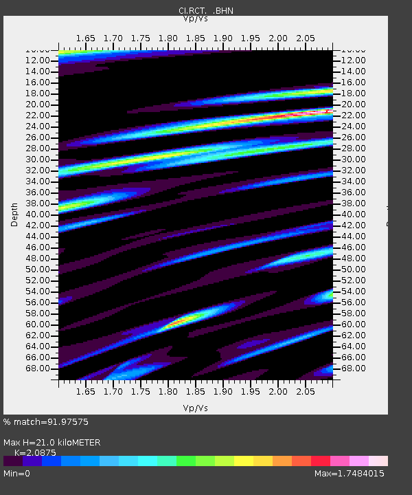
| Estimated Moho Depth: |
21.0 km |
| Estimated Crust Vp/Vs: |
2.09 |
| Assumed Crust Vp: |
6.291 km/s |
| Estimated Crust Vs: |
3.014 km/s |
| Estimated Crust Poisson's Ratio: |
0.35 |
|
| Radial Match: |
91.97575 % |
| Radial Bump: |
386 |
| Transverse Match: |
83.44825 % |
| Transverse Bump: |
400 |
| SOD ConfigId: |
2564 |
| Insert Time: |
2010-03-05 22:11:47.817 +0000 |
| GWidth: |
2.5 |
| Max Bumps: |
400 |
| Tol: |
0.001 |
|
Signal To Noise
| Channel | StoN | STA | LTA |
| CI:RCT: :BHN:20070903T16:24:56.075005Z | 11.80668 | 1.986066E-6 | 1.6821545E-7 |
| CI:RCT: :BHE:20070903T16:24:56.075005Z | 7.8812175 | 1.3629717E-6 | 1.7293924E-7 |
| CI:RCT: :BHZ:20070903T16:24:56.075005Z | 24.13214 | 2.4494186E-6 | 1.0150027E-7 |
| Arrivals |
| Ps | 3.8 SECOND |
| PpPs | 10.0 SECOND |
| PsPs/PpSs | 14 SECOND |


