You are here: Home > Network List > CI - Caltech Regional Seismic Network Stations List
> Station RCT Rector, Visalia, CA, USA > Earthquake Result Viewer
RCT Rector, Visalia, CA, USA - Earthquake Result Viewer
| Earthquake location: |
Andreanof Islands, Aleutian Is. |
| Earthquake latitude/longitude: |
50.3/-177.5 |
| Earthquake time(UTC): |
2007/08/15 (227) 20:22:11 GMT |
| Earthquake Depth: |
9.0 km |
| Earthquake Magnitude: |
6.3 MB, 6.2 MS, 6.4 MW, 5.9 ML |
| Earthquake Catalog/Contributor: |
WHDF/NEIC |
|
| Network: |
CI Caltech Regional Seismic Network |
| Station: |
RCT Rector, Visalia, CA, USA |
| Lat/Lon: |
36.31 N/119.24 W |
| Elevation: |
107 m |
|
| Distance: |
43.6 deg |
| Az: |
85.662 deg |
| Baz: |
307.694 deg |
| Ray Param: |
0.07246911 |
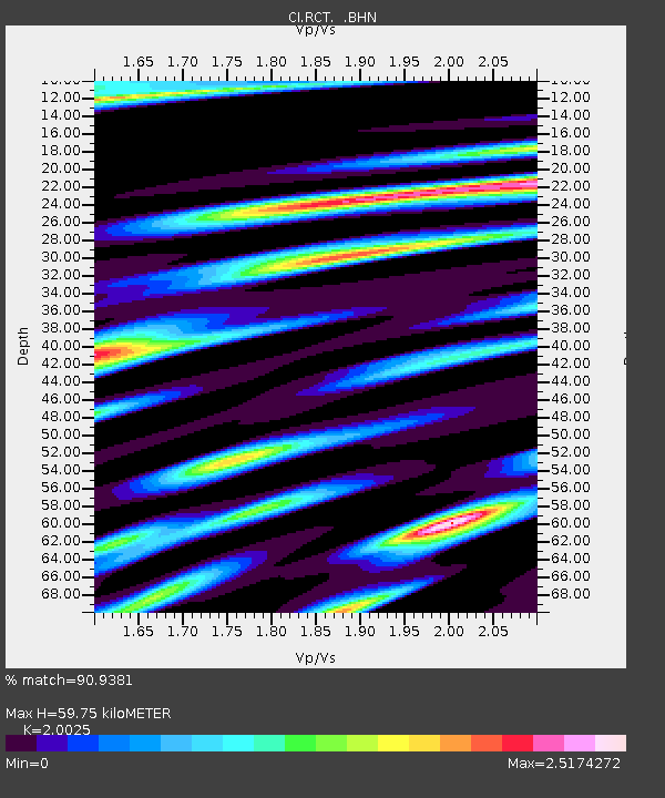
| Estimated Moho Depth: |
59.75 km |
| Estimated Crust Vp/Vs: |
2.00 |
| Assumed Crust Vp: |
6.291 km/s |
| Estimated Crust Vs: |
3.142 km/s |
| Estimated Crust Poisson's Ratio: |
0.33 |
|
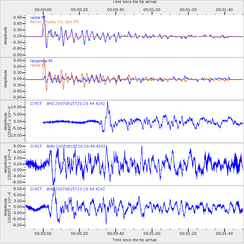
| Radial Match: |
90.9381 % |
| Radial Bump: |
400 |
| Transverse Match: |
72.68663 % |
| Transverse Bump: |
400 |
| SOD ConfigId: |
2564 |
| Insert Time: |
2010-03-05 22:11:51.736 +0000 |
| GWidth: |
2.5 |
| Max Bumps: |
400 |
| Tol: |
0.001 |
|
Signal To Noise
| Channel | StoN | STA | LTA |
| CI:RCT: :BHN:20070815T20:29:44.426Z | 2.4526877 | 1.8760611E-6 | 7.649001E-7 |
| CI:RCT: :BHE:20070815T20:29:44.426Z | 2.3973646 | 1.6666401E-6 | 6.951967E-7 |
| CI:RCT: :BHZ:20070815T20:29:44.426Z | 7.5130825 | 3.1856832E-6 | 4.2401814E-7 |
| Arrivals |
| Ps | 10 SECOND |
| PpPs | 27 SECOND |
| PsPs/PpSs | 37 SECOND |


