You are here: Home > Network List > CI - Caltech Regional Seismic Network Stations List
> Station RCT Rector, Visalia, CA, USA > Earthquake Result Viewer
RCT Rector, Visalia, CA, USA - Earthquake Result Viewer
| Earthquake location: |
Vanuatu Islands |
| Earthquake latitude/longitude: |
-15.4/168.6 |
| Earthquake time(UTC): |
2007/07/15 (196) 09:27:34 GMT |
| Earthquake Depth: |
8.0 km |
| Earthquake Magnitude: |
6.0 MB, 5.8 MS, 6.1 MW, 6.0 MW |
| Earthquake Catalog/Contributor: |
WHDF/NEIC |
|
| Network: |
CI Caltech Regional Seismic Network |
| Station: |
RCT Rector, Visalia, CA, USA |
| Lat/Lon: |
36.31 N/119.24 W |
| Elevation: |
107 m |
|
| Distance: |
85.2 deg |
| Az: |
50.498 deg |
| Baz: |
247.138 deg |
| Ray Param: |
0.04492406 |
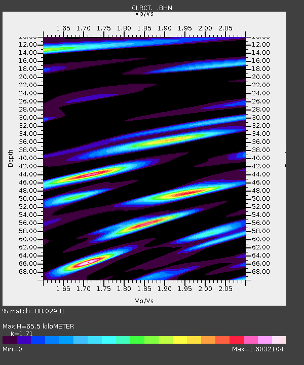
| Estimated Moho Depth: |
65.5 km |
| Estimated Crust Vp/Vs: |
1.71 |
| Assumed Crust Vp: |
6.291 km/s |
| Estimated Crust Vs: |
3.679 km/s |
| Estimated Crust Poisson's Ratio: |
0.24 |
|
| Radial Match: |
88.02931 % |
| Radial Bump: |
400 |
| Transverse Match: |
82.61982 % |
| Transverse Bump: |
400 |
| SOD ConfigId: |
2564 |
| Insert Time: |
2010-03-05 22:11:55.509 +0000 |
| GWidth: |
2.5 |
| Max Bumps: |
400 |
| Tol: |
0.001 |
|
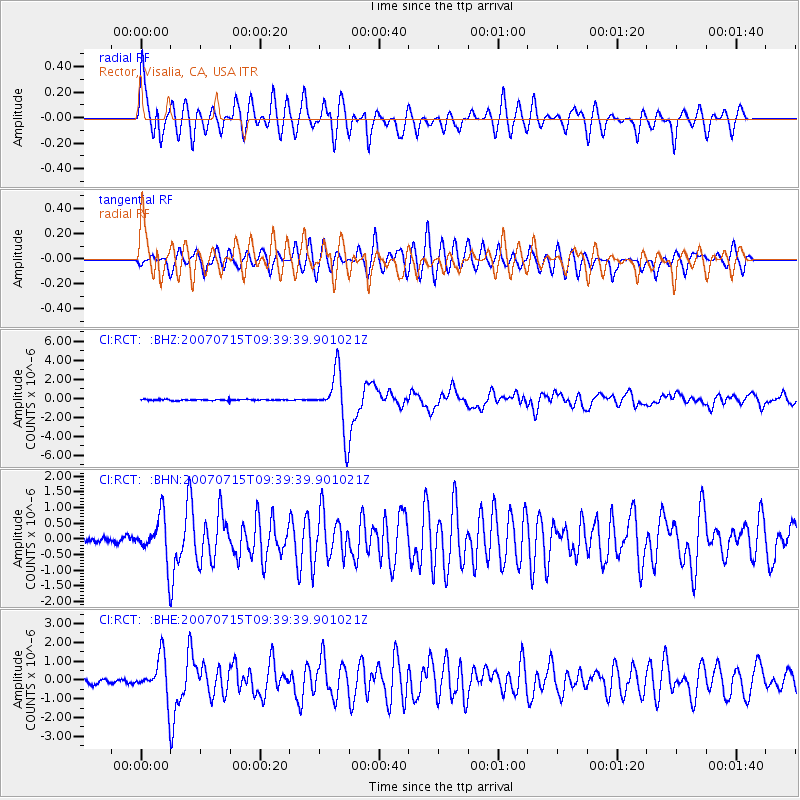
Signal To Noise
| Channel | StoN | STA | LTA |
| CI:RCT: :BHN:20070715T09:39:39.901021Z | 5.155319 | 6.9101185E-7 | 1.3403861E-7 |
| CI:RCT: :BHE:20070715T09:39:39.901021Z | 7.1447315 | 1.0896057E-6 | 1.5250477E-7 |
| CI:RCT: :BHZ:20070715T09:39:39.901021Z | 49.741905 | 3.026868E-6 | 6.085146E-8 |
| Arrivals |
| Ps | 7.6 SECOND |
| PpPs | 28 SECOND |
| PsPs/PpSs | 35 SECOND |


