You are here: Home > Network List > CI - Caltech Regional Seismic Network Stations List
> Station RCT Rector, Visalia, CA, USA > Earthquake Result Viewer
RCT Rector, Visalia, CA, USA - Earthquake Result Viewer
| Earthquake location: |
Solomon Islands |
| Earthquake latitude/longitude: |
-7.0/155.9 |
| Earthquake time(UTC): |
2007/04/27 (117) 13:49:28 GMT |
| Earthquake Depth: |
46 km |
| Earthquake Magnitude: |
5.8 MB, 5.5 MS, 5.8 MW, 5.7 MW |
| Earthquake Catalog/Contributor: |
WHDF/NEIC |
|
| Network: |
CI Caltech Regional Seismic Network |
| Station: |
RCT Rector, Visalia, CA, USA |
| Lat/Lon: |
36.31 N/119.24 W |
| Elevation: |
107 m |
|
| Distance: |
89.9 deg |
| Az: |
53.559 deg |
| Baz: |
261.364 deg |
| Ray Param: |
0.0417034 |
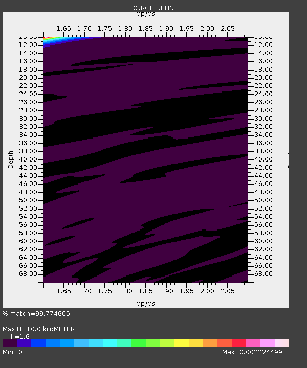
| Estimated Moho Depth: |
10.0 km |
| Estimated Crust Vp/Vs: |
1.60 |
| Assumed Crust Vp: |
6.291 km/s |
| Estimated Crust Vs: |
3.932 km/s |
| Estimated Crust Poisson's Ratio: |
0.18 |
|
| Radial Match: |
99.774605 % |
| Radial Bump: |
33 |
| Transverse Match: |
99.57346 % |
| Transverse Bump: |
36 |
| SOD ConfigId: |
2564 |
| Insert Time: |
2010-03-05 22:12:00.086 +0000 |
| GWidth: |
2.5 |
| Max Bumps: |
400 |
| Tol: |
0.001 |
|
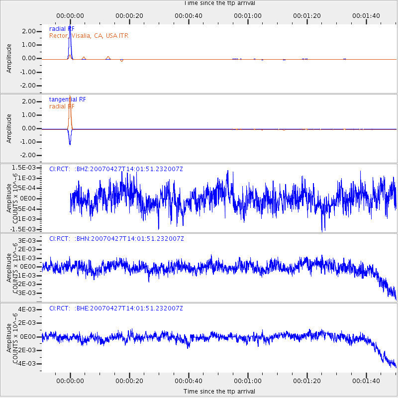
Signal To Noise
| Channel | StoN | STA | LTA |
| CI:RCT: :BHN:20070427T14:01:51.232007Z | 0.8141837 | 4.0637002E-10 | 4.991134E-10 |
| CI:RCT: :BHE:20070427T14:01:51.232007Z | 1.129277 | 5.451543E-10 | 4.827463E-10 |
| CI:RCT: :BHZ:20070427T14:01:51.232007Z | 1.1006585 | 4.706259E-10 | 4.2758572E-10 |
| Arrivals |
| Ps | 1.0 SECOND |
| PpPs | 4.0 SECOND |
| PsPs/PpSs | 5.0 SECOND |


