You are here: Home > Network List > CI - Caltech Regional Seismic Network Stations List
> Station RCT Rector, Visalia, CA, USA > Earthquake Result Viewer
RCT Rector, Visalia, CA, USA - Earthquake Result Viewer
| Earthquake location: |
Solomon Islands |
| Earthquake latitude/longitude: |
-7.8/155.7 |
| Earthquake time(UTC): |
2007/04/24 (114) 12:14:21 GMT |
| Earthquake Depth: |
10 km |
| Earthquake Magnitude: |
5.5 MB, 5.2 MS, 5.4 MW |
| Earthquake Catalog/Contributor: |
WHDF/NEIC |
|
| Network: |
CI Caltech Regional Seismic Network |
| Station: |
RCT Rector, Visalia, CA, USA |
| Lat/Lon: |
36.31 N/119.24 W |
| Elevation: |
107 m |
|
| Distance: |
90.6 deg |
| Az: |
53.596 deg |
| Baz: |
260.863 deg |
| Ray Param: |
0.0416601 |
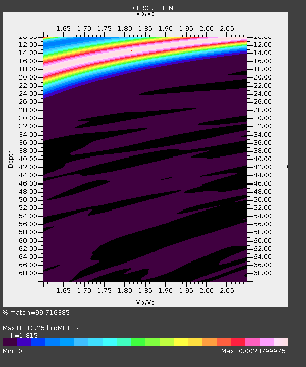
| Estimated Moho Depth: |
13.25 km |
| Estimated Crust Vp/Vs: |
1.82 |
| Assumed Crust Vp: |
6.291 km/s |
| Estimated Crust Vs: |
3.466 km/s |
| Estimated Crust Poisson's Ratio: |
0.28 |
|
| Radial Match: |
99.716385 % |
| Radial Bump: |
27 |
| Transverse Match: |
99.41663 % |
| Transverse Bump: |
42 |
| SOD ConfigId: |
2564 |
| Insert Time: |
2010-03-05 22:12:03.224 +0000 |
| GWidth: |
2.5 |
| Max Bumps: |
400 |
| Tol: |
0.001 |
|
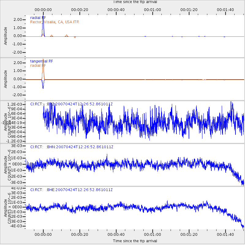
Signal To Noise
| Channel | StoN | STA | LTA |
| CI:RCT: :BHN:20070424T12:26:52.861011Z | 0.7562595 | 4.0900505E-10 | 5.4082633E-10 |
| CI:RCT: :BHE:20070424T12:26:52.861011Z | 0.8697062 | 5.29809E-10 | 6.091816E-10 |
| CI:RCT: :BHZ:20070424T12:26:52.861011Z | 1.1408343 | 5.0978777E-10 | 4.4685525E-10 |
| Arrivals |
| Ps | 1.8 SECOND |
| PpPs | 5.8 SECOND |
| PsPs/PpSs | 7.6 SECOND |


